You are here: Home > Network List > TS - TERRAscope (Southern California Seismic Network) Stations List
> Station GPO China Lake , California, USA > Earthquake Result Viewer
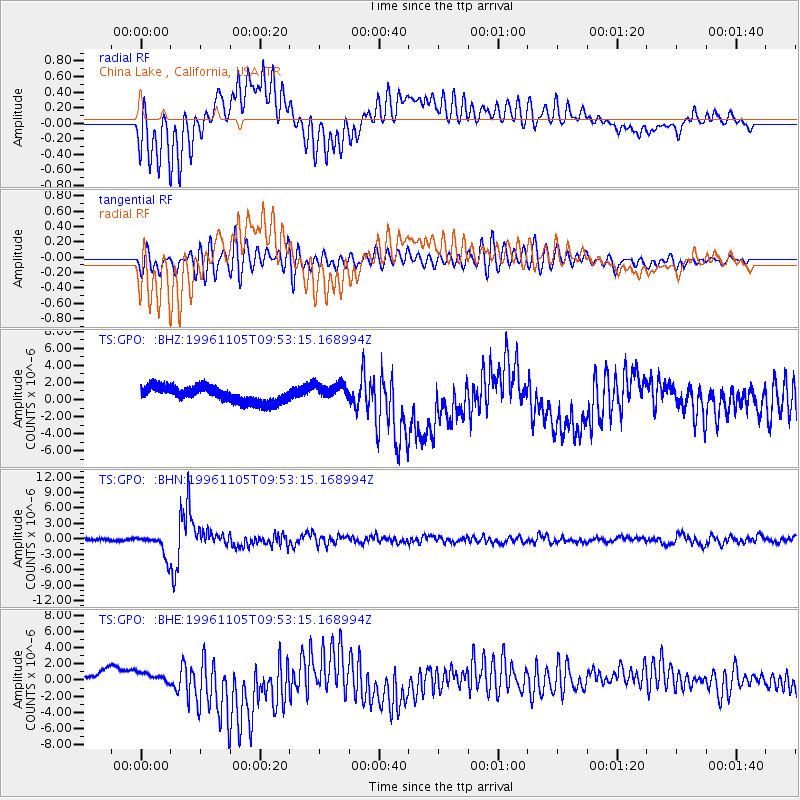
GPO China Lake , California, USA - Earthquake Result Viewer
*The percent match for this event was below the threshold and hence no stack was calculated.
| Earthquake location: |
Kermadec Islands Region |
| Earthquake latitude/longitude: |
-31.2/180.0 |
| Earthquake time(UTC): |
1996/11/05 (310) 09:41:34 GMT |
| Earthquake Depth: |
369 km |
| Earthquake Magnitude: |
5.9 MB, 6.8 UNKNOWN, 6.7 MW |
| Earthquake Catalog/Contributor: |
WHDF/NEIC |
|
| Network: |
TS TERRAscope (Southern California Seismic Network) |
| Station: |
GPO China Lake , California, USA |
| Lat/Lon: |
35.65 N/117.66 W |
| Elevation: |
735 m |
|
| Distance: |
88.5 deg |
| Az: |
46.187 deg |
| Baz: |
229.423 deg |
| Ray Param: |
$rayparam |
*The percent match for this event was below the threshold and hence was not used in the summary stack. |
|
| Radial Match: |
64.62099 % |
| Radial Bump: |
400 |
| Transverse Match: |
72.240616 % |
| Transverse Bump: |
400 |
| SOD ConfigId: |
4480 |
| Insert Time: |
2010-02-26 14:14:30.508 +0000 |
| GWidth: |
2.5 |
| Max Bumps: |
400 |
| Tol: |
0.001 |
|
Signal To Noise
| Channel | StoN | STA | LTA |
| TS:GPO: :BHN:19961105T09:53:15.168994Z | 7.4048433 | 2.1601231E-6 | 2.917176E-7 |
| TS:GPO: :BHE:19961105T09:53:15.168994Z | 1.1603032 | 4.7071725E-7 | 4.0568466E-7 |
| TS:GPO: :BHZ:19961105T09:53:15.168994Z | 1.1019833 | 1.014012E-6 | 9.2016995E-7 |
| Arrivals |
| Ps | |
| PpPs | |
| PsPs/PpSs | |


