You are here: Home > Network List > TA - USArray Transportable Network (new EarthScope stations) Stations List
> Station W20A Ramah, NM, USA > Earthquake Result Viewer
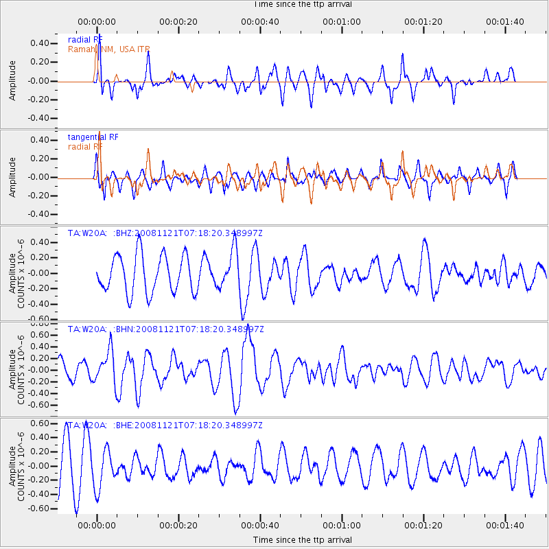
W20A Ramah, NM, USA - Earthquake Result Viewer
*The percent match for this event was below the threshold and hence no stack was calculated.
| Earthquake location: |
Solomon Islands |
| Earthquake latitude/longitude: |
-8.9/159.6 |
| Earthquake time(UTC): |
2008/11/21 (326) 07:05:34 GMT |
| Earthquake Depth: |
118 km |
| Earthquake Magnitude: |
6.0 MB, 6.1 MW, 6.0 MW |
| Earthquake Catalog/Contributor: |
WHDF/NEIC |
|
| Network: |
TA USArray Transportable Network (new EarthScope stations) |
| Station: |
W20A Ramah, NM, USA |
| Lat/Lon: |
35.13 N/108.50 W |
| Elevation: |
2110 m |
|
| Distance: |
96.7 deg |
| Az: |
55.568 deg |
| Baz: |
263.791 deg |
| Ray Param: |
$rayparam |
*The percent match for this event was below the threshold and hence was not used in the summary stack. |
|
| Radial Match: |
65.42031 % |
| Radial Bump: |
400 |
| Transverse Match: |
62.31319 % |
| Transverse Bump: |
400 |
| SOD ConfigId: |
2658 |
| Insert Time: |
2010-03-06 23:05:34.346 +0000 |
| GWidth: |
2.5 |
| Max Bumps: |
400 |
| Tol: |
0.001 |
|
Signal To Noise
| Channel | StoN | STA | LTA |
| TA:W20A: :BHN:20081121T07:18:20.348997Z | 1.8940191 | 2.9203756E-7 | 1.5418935E-7 |
| TA:W20A: :BHE:20081121T07:18:20.348997Z | 1.0204952 | 2.689721E-7 | 2.6357017E-7 |
| TA:W20A: :BHZ:20081121T07:18:20.348997Z | 1.0346866 | 2.5084557E-7 | 2.4243627E-7 |
| Arrivals |
| Ps | |
| PpPs | |
| PsPs/PpSs | |


