You are here: Home > Network List > TS - TERRAscope (Southern California Seismic Network) Stations List
> Station GPO China Lake , California, USA > Earthquake Result Viewer
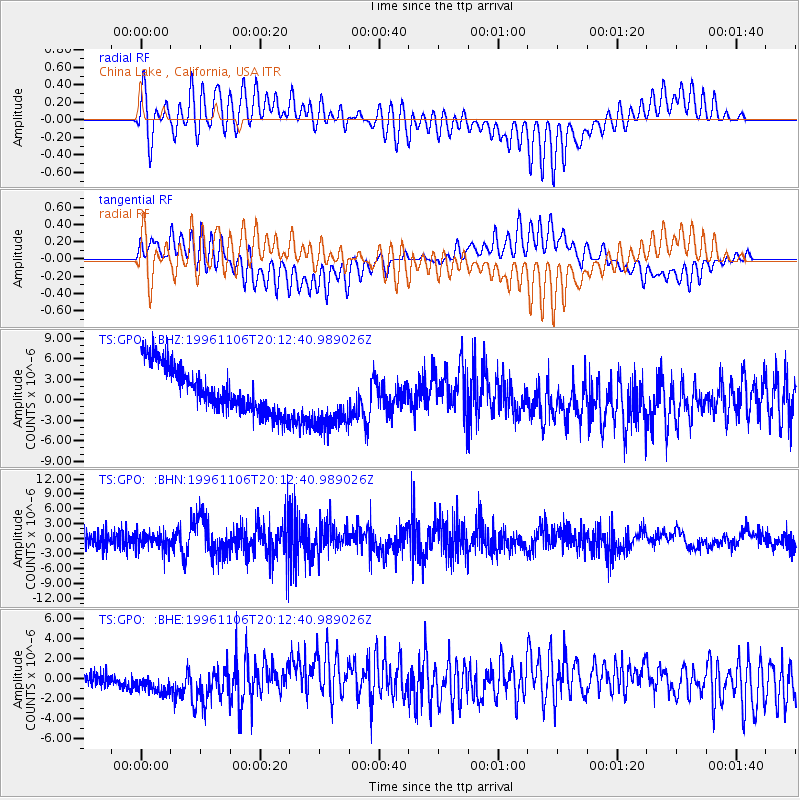
GPO China Lake , California, USA - Earthquake Result Viewer
*The percent match for this event was below the threshold and hence no stack was calculated.
| Earthquake location: |
Bonin Islands, Japan Region |
| Earthquake latitude/longitude: |
28.0/143.5 |
| Earthquake time(UTC): |
1996/11/06 (311) 20:00:58 GMT |
| Earthquake Depth: |
9.0 km |
| Earthquake Magnitude: |
6.4 MB, 6.5 MS, 6.6 UNKNOWN, 6.4 ME |
| Earthquake Catalog/Contributor: |
WHDF/NEIC |
|
| Network: |
TS TERRAscope (Southern California Seismic Network) |
| Station: |
GPO China Lake , California, USA |
| Lat/Lon: |
35.65 N/117.66 W |
| Elevation: |
735 m |
|
| Distance: |
80.7 deg |
| Az: |
54.634 deg |
| Baz: |
297.703 deg |
| Ray Param: |
$rayparam |
*The percent match for this event was below the threshold and hence was not used in the summary stack. |
|
| Radial Match: |
53.07586 % |
| Radial Bump: |
400 |
| Transverse Match: |
45.9748 % |
| Transverse Bump: |
400 |
| SOD ConfigId: |
4480 |
| Insert Time: |
2010-02-26 14:14:31.271 +0000 |
| GWidth: |
2.5 |
| Max Bumps: |
400 |
| Tol: |
0.001 |
|
Signal To Noise
| Channel | StoN | STA | LTA |
| TS:GPO: :BHN:19961106T20:12:40.989026Z | 1.0524436 | 1.7099158E-6 | 1.6247101E-6 |
| TS:GPO: :BHE:19961106T20:12:40.989026Z | 1.7200702 | 1.8111114E-6 | 1.0529287E-6 |
| TS:GPO: :BHZ:19961106T20:12:40.989026Z | 1.3950721 | 4.660174E-6 | 3.3404538E-6 |
| Arrivals |
| Ps | |
| PpPs | |
| PsPs/PpSs | |


