You are here: Home > Network List > CN - Canadian National Seismograph Network Stations List
> Station UBRB Upper Baezaeko River, BC, CA > Earthquake Result Viewer
UBRB Upper Baezaeko River, BC, CA - Earthquake Result Viewer
| Earthquake location: |
El Salvador |
| Earthquake latitude/longitude: |
13.1/-89.4 |
| Earthquake time(UTC): |
2019/05/30 (150) 09:03:31 GMT |
| Earthquake Depth: |
10 km |
| Earthquake Magnitude: |
6.6 Mi |
| Earthquake Catalog/Contributor: |
NEIC PDE/at |
|
| Network: |
CN Canadian National Seismograph Network |
| Station: |
UBRB Upper Baezaeko River, BC, CA |
| Lat/Lon: |
52.89 N/124.08 W |
| Elevation: |
1241 m |
|
| Distance: |
48.3 deg |
| Az: |
332.489 deg |
| Baz: |
132.037 deg |
| Ray Param: |
0.06942371 |
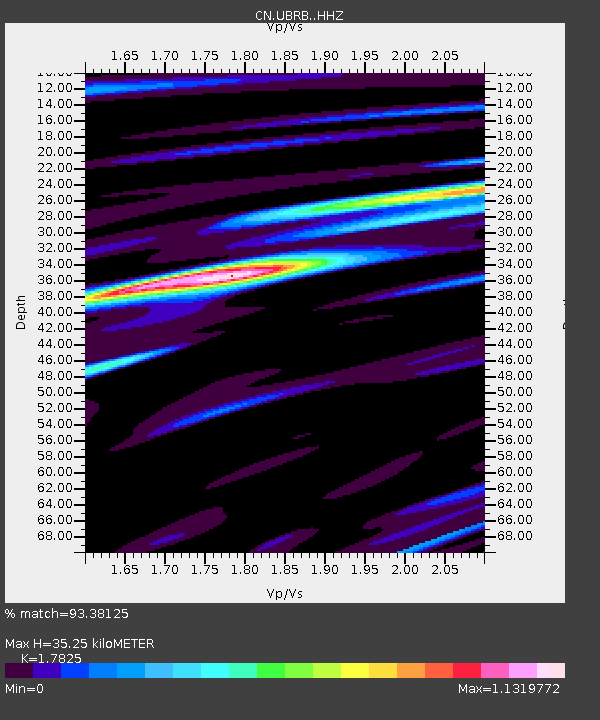
| Estimated Moho Depth: |
35.25 km |
| Estimated Crust Vp/Vs: |
1.78 |
| Assumed Crust Vp: |
6.566 km/s |
| Estimated Crust Vs: |
3.684 km/s |
| Estimated Crust Poisson's Ratio: |
0.27 |
|
| Radial Match: |
93.38125 % |
| Radial Bump: |
307 |
| Transverse Match: |
81.73786 % |
| Transverse Bump: |
400 |
| SOD ConfigId: |
18369291 |
| Insert Time: |
2019-06-13 09:07:45.155 +0000 |
| GWidth: |
2.5 |
| Max Bumps: |
400 |
| Tol: |
0.001 |
|

Signal To Noise
| Channel | StoN | STA | LTA |
| CN:UBRB: :HHZ:20190530T09:11:41.700012Z | 16.026142 | 2.1200135E-6 | 1.322847E-7 |
| CN:UBRB: :HHN:20190530T09:11:41.700012Z | 12.347994 | 1.2376065E-6 | 1.0022733E-7 |
| CN:UBRB: :HHE:20190530T09:11:41.700012Z | 8.61265 | 8.034889E-7 | 9.3291725E-8 |
| Arrivals |
| Ps | 4.5 SECOND |
| PpPs | 14 SECOND |
| PsPs/PpSs | 19 SECOND |


