You are here: Home > Network List > TA - USArray Transportable Network (new EarthScope stations) Stations List
> Station W20A Ramah, NM, USA > Earthquake Result Viewer
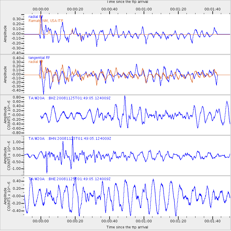
W20A Ramah, NM, USA - Earthquake Result Viewer
*The percent match for this event was below the threshold and hence no stack was calculated.
| Earthquake location: |
Kermadec Islands, New Zealand |
| Earthquake latitude/longitude: |
-30.2/-177.9 |
| Earthquake time(UTC): |
2008/11/25 (330) 01:36:30 GMT |
| Earthquake Depth: |
35 km |
| Earthquake Magnitude: |
5.6 MB, 5.3 MS, 5.6 MW, 5.6 MW |
| Earthquake Catalog/Contributor: |
WHDF/NEIC |
|
| Network: |
TA USArray Transportable Network (new EarthScope stations) |
| Station: |
W20A Ramah, NM, USA |
| Lat/Lon: |
35.13 N/108.50 W |
| Elevation: |
2110 m |
|
| Distance: |
92.1 deg |
| Az: |
50.148 deg |
| Baz: |
234.141 deg |
| Ray Param: |
$rayparam |
*The percent match for this event was below the threshold and hence was not used in the summary stack. |
|
| Radial Match: |
51.84423 % |
| Radial Bump: |
400 |
| Transverse Match: |
47.811825 % |
| Transverse Bump: |
353 |
| SOD ConfigId: |
2658 |
| Insert Time: |
2010-03-06 23:06:02.645 +0000 |
| GWidth: |
2.5 |
| Max Bumps: |
400 |
| Tol: |
0.001 |
|
Signal To Noise
| Channel | StoN | STA | LTA |
| TA:W20A: :BHN:20081125T01:49:05.124009Z | 3.0391831 | 3.935724E-7 | 1.2949941E-7 |
| TA:W20A: :BHE:20081125T01:49:05.124009Z | 0.6850324 | 1.3873354E-7 | 2.0252114E-7 |
| TA:W20A: :BHZ:20081125T01:49:05.124009Z | 1.2198132 | 1.9288753E-7 | 1.5812874E-7 |
| Arrivals |
| Ps | |
| PpPs | |
| PsPs/PpSs | |


