You are here: Home > Network List > N4 - Central and EAstern US Network Stations List
> Station F64A Sherman, ME, USA > Earthquake Result Viewer
F64A Sherman, ME, USA - Earthquake Result Viewer
| Earthquake location: |
El Salvador |
| Earthquake latitude/longitude: |
13.1/-89.4 |
| Earthquake time(UTC): |
2019/05/30 (150) 09:03:31 GMT |
| Earthquake Depth: |
10 km |
| Earthquake Magnitude: |
6.6 Mi |
| Earthquake Catalog/Contributor: |
NEIC PDE/at |
|
| Network: |
N4 Central and EAstern US Network |
| Station: |
F64A Sherman, ME, USA |
| Lat/Lon: |
45.86 N/68.35 W |
| Elevation: |
179 m |
|
| Distance: |
37.2 deg |
| Az: |
24.505 deg |
| Baz: |
215.328 deg |
| Ray Param: |
0.07628533 |
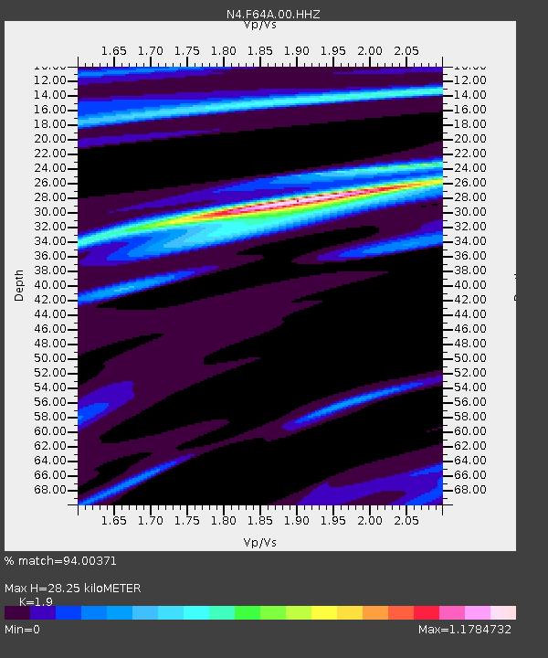
| Estimated Moho Depth: |
28.25 km |
| Estimated Crust Vp/Vs: |
1.90 |
| Assumed Crust Vp: |
6.419 km/s |
| Estimated Crust Vs: |
3.379 km/s |
| Estimated Crust Poisson's Ratio: |
0.31 |
|
| Radial Match: |
94.00371 % |
| Radial Bump: |
190 |
| Transverse Match: |
68.0867 % |
| Transverse Bump: |
400 |
| SOD ConfigId: |
18369291 |
| Insert Time: |
2019-06-13 09:09:12.346 +0000 |
| GWidth: |
2.5 |
| Max Bumps: |
400 |
| Tol: |
0.001 |
|

Signal To Noise
| Channel | StoN | STA | LTA |
| N4:F64A:00:HHZ:20190530T09:10:11.169006Z | 0.8958982 | 7.842221E-7 | 8.753473E-7 |
| N4:F64A:00:HH1:20190530T09:10:11.169006Z | 1.5628756 | 6.1484894E-7 | 3.9340875E-7 |
| N4:F64A:00:HH2:20190530T09:10:11.169006Z | 1.2634687 | 4.8607995E-7 | 3.8471865E-7 |
| Arrivals |
| Ps | 4.2 SECOND |
| PpPs | 12 SECOND |
| PsPs/PpSs | 16 SECOND |


