You are here: Home > Network List > TA - USArray Transportable Network (new EarthScope stations) Stations List
> Station W20A Ramah, NM, USA > Earthquake Result Viewer
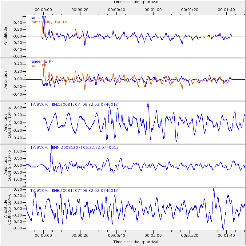
W20A Ramah, NM, USA - Earthquake Result Viewer
*The percent match for this event was below the threshold and hence no stack was calculated.
| Earthquake location: |
Northern Mid-Atlantic Ridge |
| Earthquake latitude/longitude: |
13.4/-44.8 |
| Earthquake time(UTC): |
2008/12/07 (342) 06:23:09 GMT |
| Earthquake Depth: |
10 km |
| Earthquake Magnitude: |
5.6 MB, 5.3 MS, 5.7 MW |
| Earthquake Catalog/Contributor: |
WHDF/NEIC |
|
| Network: |
TA USArray Transportable Network (new EarthScope stations) |
| Station: |
W20A Ramah, NM, USA |
| Lat/Lon: |
35.13 N/108.50 W |
| Elevation: |
2110 m |
|
| Distance: |
61.0 deg |
| Az: |
302.835 deg |
| Baz: |
93.88 deg |
| Ray Param: |
$rayparam |
*The percent match for this event was below the threshold and hence was not used in the summary stack. |
|
| Radial Match: |
70.31684 % |
| Radial Bump: |
400 |
| Transverse Match: |
68.57805 % |
| Transverse Bump: |
400 |
| SOD ConfigId: |
2658 |
| Insert Time: |
2010-03-06 23:06:12.994 +0000 |
| GWidth: |
2.5 |
| Max Bumps: |
400 |
| Tol: |
0.001 |
|
Signal To Noise
| Channel | StoN | STA | LTA |
| TA:W20A: :BHN:20081207T06:32:52.074001Z | 5.2939816 | 4.775492E-7 | 9.020605E-8 |
| TA:W20A: :BHE:20081207T06:32:52.074001Z | 1.1932763 | 1.2547717E-7 | 1.0515349E-7 |
| TA:W20A: :BHZ:20081207T06:32:52.074001Z | 1.5318042 | 2.062579E-7 | 1.346503E-7 |
| Arrivals |
| Ps | |
| PpPs | |
| PsPs/PpSs | |


