You are here: Home > Network List > NN - Western Great Basin/Eastern Sierra Nevada Stations List
> Station R11B Troy Canyon, Currant, NV, USA > Earthquake Result Viewer
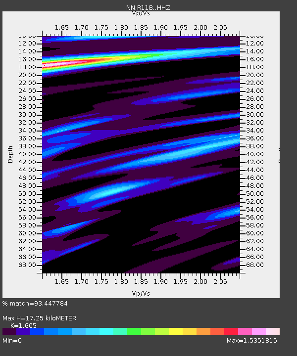
R11B Troy Canyon, Currant, NV, USA - Earthquake Result Viewer
| Earthquake location: |
El Salvador |
| Earthquake latitude/longitude: |
13.1/-89.4 |
| Earthquake time(UTC): |
2019/05/30 (150) 09:03:31 GMT |
| Earthquake Depth: |
10 km |
| Earthquake Magnitude: |
6.6 Mi |
| Earthquake Catalog/Contributor: |
NEIC PDE/at |
|
| Network: |
NN Western Great Basin/Eastern Sierra Nevada |
| Station: |
R11B Troy Canyon, Currant, NV, USA |
| Lat/Lon: |
38.35 N/115.59 W |
| Elevation: |
1767 m |
|
| Distance: |
34.3 deg |
| Az: |
321.88 deg |
| Baz: |
130.105 deg |
| Ray Param: |
0.0778335 |
| Estimated Moho Depth: |
17.25 km |
| Estimated Crust Vp/Vs: |
1.61 |
| Assumed Crust Vp: |
6.276 km/s |
| Estimated Crust Vs: |
3.91 km/s |
| Estimated Crust Poisson's Ratio: |
0.18 |
|
| Radial Match: |
93.447784 % |
| Radial Bump: |
297 |
| Transverse Match: |
69.77956 % |
| Transverse Bump: |
400 |
| SOD ConfigId: |
18369291 |
| Insert Time: |
2019-06-13 09:09:40.100 +0000 |
| GWidth: |
2.5 |
| Max Bumps: |
400 |
| Tol: |
0.001 |
|

Signal To Noise
| Channel | StoN | STA | LTA |
| NN:R11B: :HHZ:20190530T09:09:46.230011Z | 15.171469 | 1.7929168E-6 | 1.1817687E-7 |
| NN:R11B: :HHN:20190530T09:09:46.230011Z | 7.209517 | 6.7606555E-7 | 9.377404E-8 |
| NN:R11B: :HHE:20190530T09:09:46.230011Z | 10.325698 | 7.751383E-7 | 7.506885E-8 |
| Arrivals |
| Ps | 1.8 SECOND |
| PpPs | 6.6 SECOND |
| PsPs/PpSs | 8.4 SECOND |


