You are here: Home > Network List > TA - USArray Transportable Network (new EarthScope stations) Stations List
> Station W20A Ramah, NM, USA > Earthquake Result Viewer
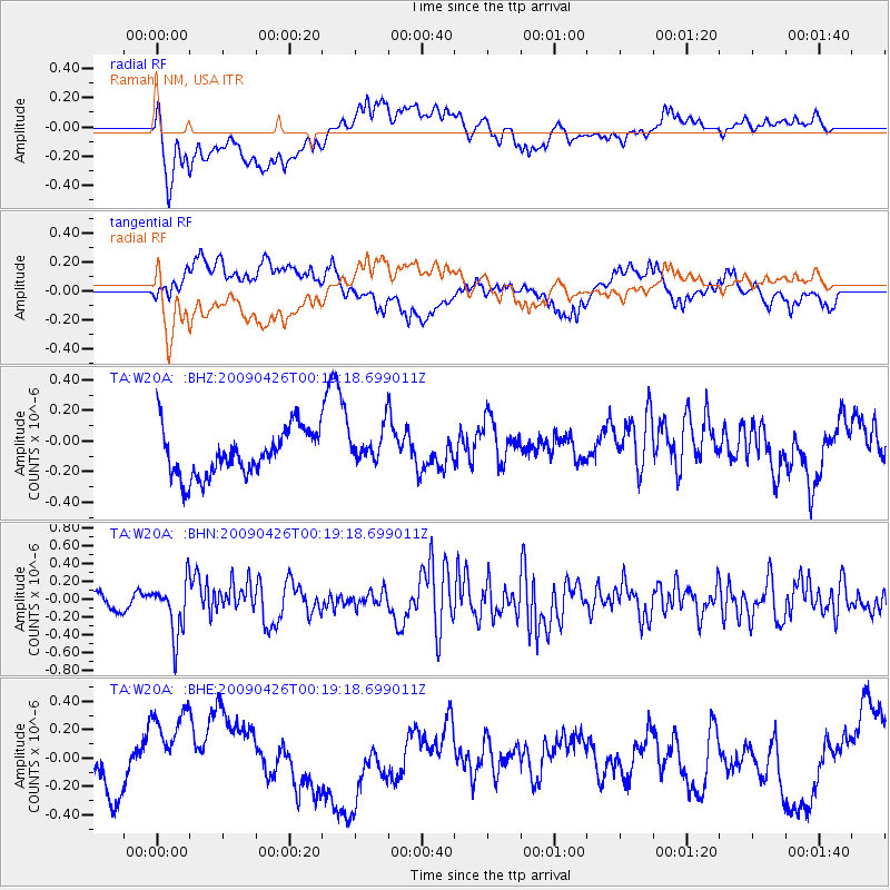
W20A Ramah, NM, USA - Earthquake Result Viewer
*The percent match for this event was below the threshold and hence no stack was calculated.
| Earthquake location: |
Kermadec Islands, New Zealand |
| Earthquake latitude/longitude: |
-30.3/-178.6 |
| Earthquake time(UTC): |
2009/04/26 (116) 00:06:53 GMT |
| Earthquake Depth: |
132 km |
| Earthquake Magnitude: |
5.5 MB, 6.1 MW, 6.1 MW |
| Earthquake Catalog/Contributor: |
WHDF/NEIC |
|
| Network: |
TA USArray Transportable Network (new EarthScope stations) |
| Station: |
W20A Ramah, NM, USA |
| Lat/Lon: |
35.13 N/108.50 W |
| Elevation: |
2110 m |
|
| Distance: |
92.6 deg |
| Az: |
50.487 deg |
| Baz: |
234.488 deg |
| Ray Param: |
$rayparam |
*The percent match for this event was below the threshold and hence was not used in the summary stack. |
|
| Radial Match: |
57.37993 % |
| Radial Bump: |
400 |
| Transverse Match: |
42.23427 % |
| Transverse Bump: |
400 |
| SOD ConfigId: |
2658 |
| Insert Time: |
2010-03-06 23:06:27.795 +0000 |
| GWidth: |
2.5 |
| Max Bumps: |
400 |
| Tol: |
0.001 |
|
Signal To Noise
| Channel | StoN | STA | LTA |
| TA:W20A: :BHN:20090426T00:19:18.699011Z | 3.254961 | 3.023907E-7 | 9.290148E-8 |
| TA:W20A: :BHE:20090426T00:19:18.699011Z | 2.126137 | 3.3939463E-7 | 1.5962972E-7 |
| TA:W20A: :BHZ:20090426T00:19:18.699011Z | 0.7372269 | 1.1288424E-7 | 1.5312007E-7 |
| Arrivals |
| Ps | |
| PpPs | |
| PsPs/PpSs | |


