You are here: Home > Network List > TA - USArray Transportable Network (new EarthScope stations) Stations List
> Station B18K Kokolik River, AK, USA > Earthquake Result Viewer
B18K Kokolik River, AK, USA - Earthquake Result Viewer
| Earthquake location: |
El Salvador |
| Earthquake latitude/longitude: |
13.1/-89.4 |
| Earthquake time(UTC): |
2019/05/30 (150) 09:03:31 GMT |
| Earthquake Depth: |
10 km |
| Earthquake Magnitude: |
6.6 Mi |
| Earthquake Catalog/Contributor: |
NEIC PDE/at |
|
| Network: |
TA USArray Transportable Network (new EarthScope stations) |
| Station: |
B18K Kokolik River, AK, USA |
| Lat/Lon: |
69.36 N/161.80 W |
| Elevation: |
222 m |
|
| Distance: |
71.6 deg |
| Az: |
339.137 deg |
| Baz: |
101.847 deg |
| Ray Param: |
0.05420232 |
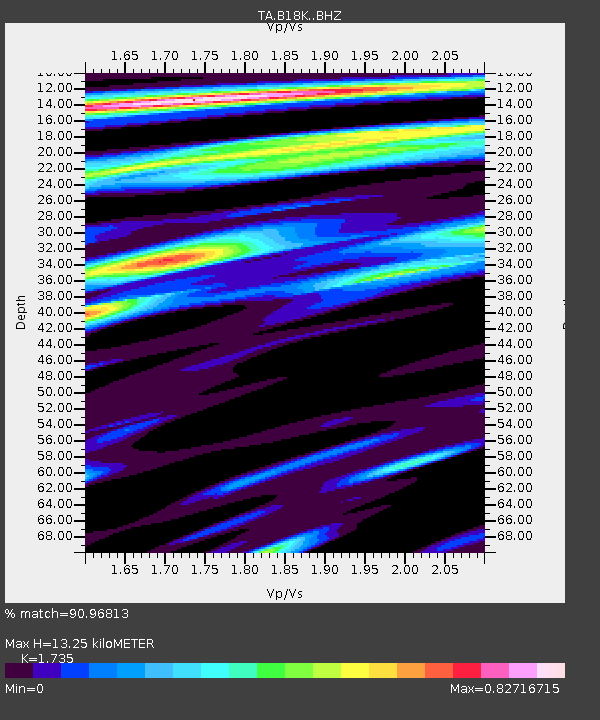
| Estimated Moho Depth: |
13.25 km |
| Estimated Crust Vp/Vs: |
1.74 |
| Assumed Crust Vp: |
5.906 km/s |
| Estimated Crust Vs: |
3.404 km/s |
| Estimated Crust Poisson's Ratio: |
0.25 |
|
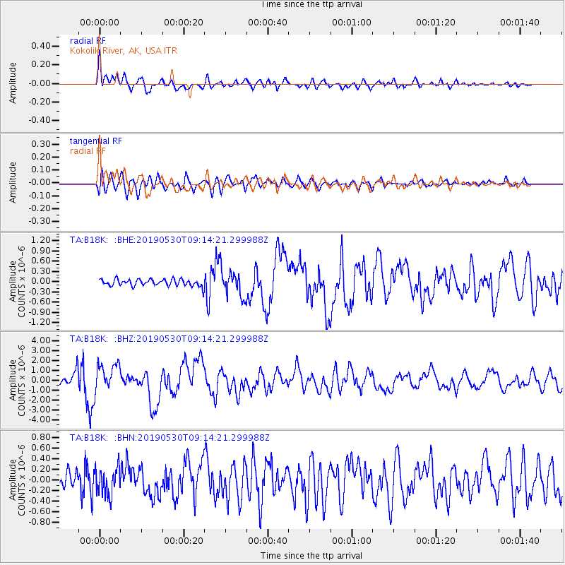
| Radial Match: |
90.96813 % |
| Radial Bump: |
400 |
| Transverse Match: |
73.49986 % |
| Transverse Bump: |
400 |
| SOD ConfigId: |
18369291 |
| Insert Time: |
2019-06-13 09:10:44.093 +0000 |
| GWidth: |
2.5 |
| Max Bumps: |
400 |
| Tol: |
0.001 |
|
Signal To Noise
| Channel | StoN | STA | LTA |
| TA:B18K: :BHZ:20190530T09:14:21.299988Z | 3.5272636 | 1.317646E-6 | 3.735604E-7 |
| TA:B18K: :BHN:20190530T09:14:21.299988Z | 1.7346897 | 2.5716363E-7 | 1.4824764E-7 |
| TA:B18K: :BHE:20190530T09:14:21.299988Z | 3.5676672 | 3.4493553E-7 | 9.668377E-8 |
| Arrivals |
| Ps | 1.7 SECOND |
| PpPs | 6.0 SECOND |
| PsPs/PpSs | 7.7 SECOND |


