You are here: Home > Network List > TA - USArray Transportable Network (new EarthScope stations) Stations List
> Station B20K Meade River, AK, USA > Earthquake Result Viewer
B20K Meade River, AK, USA - Earthquake Result Viewer
| Earthquake location: |
El Salvador |
| Earthquake latitude/longitude: |
13.1/-89.4 |
| Earthquake time(UTC): |
2019/05/30 (150) 09:03:31 GMT |
| Earthquake Depth: |
10 km |
| Earthquake Magnitude: |
6.6 Mi |
| Earthquake Catalog/Contributor: |
NEIC PDE/at |
|
| Network: |
TA USArray Transportable Network (new EarthScope stations) |
| Station: |
B20K Meade River, AK, USA |
| Lat/Lon: |
70.01 N/157.16 W |
| Elevation: |
75 m |
|
| Distance: |
70.2 deg |
| Az: |
340.22 deg |
| Baz: |
106.551 deg |
| Ray Param: |
0.055131566 |
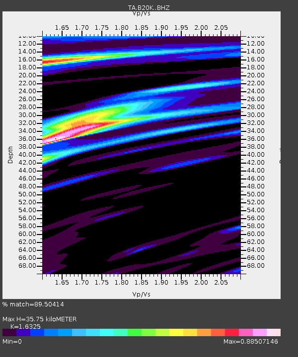
| Estimated Moho Depth: |
35.75 km |
| Estimated Crust Vp/Vs: |
1.63 |
| Assumed Crust Vp: |
6.048 km/s |
| Estimated Crust Vs: |
3.705 km/s |
| Estimated Crust Poisson's Ratio: |
0.20 |
|
| Radial Match: |
89.50414 % |
| Radial Bump: |
400 |
| Transverse Match: |
78.17197 % |
| Transverse Bump: |
400 |
| SOD ConfigId: |
18369291 |
| Insert Time: |
2019-06-13 09:10:45.029 +0000 |
| GWidth: |
2.5 |
| Max Bumps: |
400 |
| Tol: |
0.001 |
|

Signal To Noise
| Channel | StoN | STA | LTA |
| TA:B20K: :BHZ:20190530T09:14:12.750Z | 3.0664434 | 1.2097572E-6 | 3.9451476E-7 |
| TA:B20K: :BHN:20190530T09:14:12.750Z | 2.7836113 | 3.491394E-7 | 1.254268E-7 |
| TA:B20K: :BHE:20190530T09:14:12.750Z | 4.1229777 | 5.1976684E-7 | 1.260659E-7 |
| Arrivals |
| Ps | 3.9 SECOND |
| PpPs | 15 SECOND |
| PsPs/PpSs | 19 SECOND |


