You are here: Home > Network List > TA - USArray Transportable Network (new EarthScope stations) Stations List
> Station E23K Chandalar, AK, USA > Earthquake Result Viewer
E23K Chandalar, AK, USA - Earthquake Result Viewer
| Earthquake location: |
El Salvador |
| Earthquake latitude/longitude: |
13.1/-89.4 |
| Earthquake time(UTC): |
2019/05/30 (150) 09:03:31 GMT |
| Earthquake Depth: |
10 km |
| Earthquake Magnitude: |
6.6 Mi |
| Earthquake Catalog/Contributor: |
NEIC PDE/at |
|
| Network: |
TA USArray Transportable Network (new EarthScope stations) |
| Station: |
E23K Chandalar, AK, USA |
| Lat/Lon: |
68.06 N/149.62 W |
| Elevation: |
1084 m |
|
| Distance: |
67.0 deg |
| Az: |
339.238 deg |
| Baz: |
113.233 deg |
| Ray Param: |
0.05724453 |
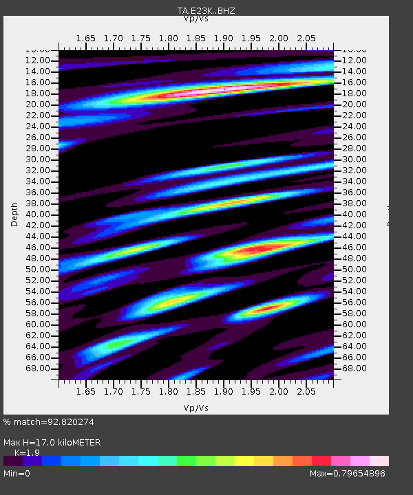
| Estimated Moho Depth: |
17.0 km |
| Estimated Crust Vp/Vs: |
1.90 |
| Assumed Crust Vp: |
6.316 km/s |
| Estimated Crust Vs: |
3.324 km/s |
| Estimated Crust Poisson's Ratio: |
0.31 |
|
| Radial Match: |
92.820274 % |
| Radial Bump: |
400 |
| Transverse Match: |
88.45559 % |
| Transverse Bump: |
400 |
| SOD ConfigId: |
18369291 |
| Insert Time: |
2019-06-13 09:11:00.692 +0000 |
| GWidth: |
2.5 |
| Max Bumps: |
400 |
| Tol: |
0.001 |
|

Signal To Noise
| Channel | StoN | STA | LTA |
| TA:E23K: :BHZ:20190530T09:13:52.724976Z | 5.738676 | 1.1561008E-6 | 2.0145775E-7 |
| TA:E23K: :BHN:20190530T09:13:52.724976Z | 10.150194 | 5.2144065E-7 | 5.1372478E-8 |
| TA:E23K: :BHE:20190530T09:13:52.724976Z | 8.9708 | 6.157628E-7 | 6.864079E-8 |
| Arrivals |
| Ps | 2.5 SECOND |
| PpPs | 7.5 SECOND |
| PsPs/PpSs | 10 SECOND |


