You are here: Home > Network List > TS - TERRAscope (Southern California Seismic Network) Stations List
> Station GPO China Lake , California, USA > Earthquake Result Viewer
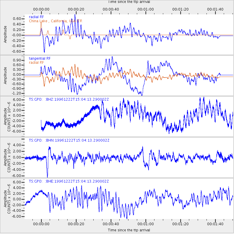
GPO China Lake , California, USA - Earthquake Result Viewer
*The percent match for this event was below the threshold and hence no stack was calculated.
| Earthquake location: |
Eastern Sea Of Japan |
| Earthquake latitude/longitude: |
43.2/138.9 |
| Earthquake time(UTC): |
1996/12/22 (357) 14:53:27 GMT |
| Earthquake Depth: |
227 km |
| Earthquake Magnitude: |
6.0 MB, 6.5 UNKNOWN, 6.5 MW |
| Earthquake Catalog/Contributor: |
WHDF/NEIC |
|
| Network: |
TS TERRAscope (Southern California Seismic Network) |
| Station: |
GPO China Lake , California, USA |
| Lat/Lon: |
35.65 N/117.66 W |
| Elevation: |
735 m |
|
| Distance: |
75.1 deg |
| Az: |
55.074 deg |
| Baz: |
312.603 deg |
| Ray Param: |
$rayparam |
*The percent match for this event was below the threshold and hence was not used in the summary stack. |
|
| Radial Match: |
42.5415 % |
| Radial Bump: |
400 |
| Transverse Match: |
40.107468 % |
| Transverse Bump: |
400 |
| SOD ConfigId: |
4480 |
| Insert Time: |
2010-02-26 14:14:34.737 +0000 |
| GWidth: |
2.5 |
| Max Bumps: |
400 |
| Tol: |
0.001 |
|
Signal To Noise
| Channel | StoN | STA | LTA |
| TS:GPO: :BHN:19961222T15:04:13.290002Z | 6.17915 | 2.1981602E-6 | 3.5573825E-7 |
| TS:GPO: :BHE:19961222T15:04:13.290002Z | 5.197762 | 3.5710937E-6 | 6.8704446E-7 |
| TS:GPO: :BHZ:19961222T15:04:13.290002Z | 5.7395544 | 6.0119964E-6 | 1.0474674E-6 |
| Arrivals |
| Ps | |
| PpPs | |
| PsPs/PpSs | |


