You are here: Home > Network List > TA - USArray Transportable Network (new EarthScope stations) Stations List
> Station W20A Ramah, NM, USA > Earthquake Result Viewer
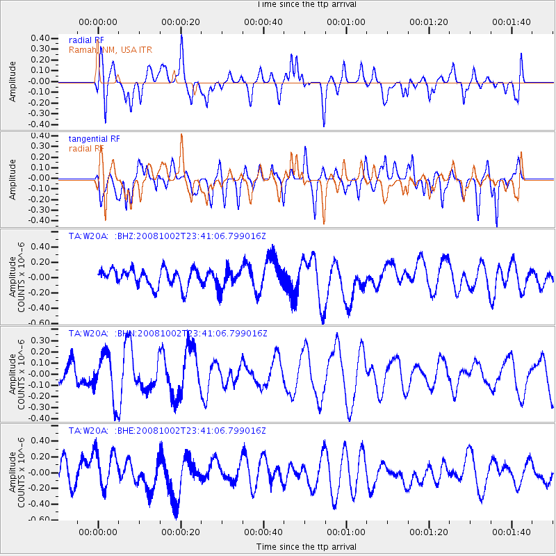
W20A Ramah, NM, USA - Earthquake Result Viewer
*The percent match for this event was below the threshold and hence no stack was calculated.
| Earthquake location: |
Southeast Of Loyalty Islands |
| Earthquake latitude/longitude: |
-23.0/169.9 |
| Earthquake time(UTC): |
2008/10/02 (276) 23:28:09 GMT |
| Earthquake Depth: |
10 km |
| Earthquake Magnitude: |
5.8 MB, 5.5 MS, 5.8 MW, 5.8 MW |
| Earthquake Catalog/Contributor: |
WHDF/NEIC |
|
| Network: |
TA USArray Transportable Network (new EarthScope stations) |
| Station: |
W20A Ramah, NM, USA |
| Lat/Lon: |
35.13 N/108.50 W |
| Elevation: |
2110 m |
|
| Distance: |
96.5 deg |
| Az: |
54.707 deg |
| Baz: |
246.547 deg |
| Ray Param: |
$rayparam |
*The percent match for this event was below the threshold and hence was not used in the summary stack. |
|
| Radial Match: |
64.54679 % |
| Radial Bump: |
400 |
| Transverse Match: |
51.42837 % |
| Transverse Bump: |
400 |
| SOD ConfigId: |
2556 |
| Insert Time: |
2010-03-06 23:07:00.059 +0000 |
| GWidth: |
2.5 |
| Max Bumps: |
400 |
| Tol: |
0.001 |
|
Signal To Noise
| Channel | StoN | STA | LTA |
| TA:W20A: :BHN:20081002T23:41:06.799016Z | 1.6010803 | 2.131001E-7 | 1.330977E-7 |
| TA:W20A: :BHE:20081002T23:41:06.799016Z | 1.9546378 | 2.5423432E-7 | 1.3006724E-7 |
| TA:W20A: :BHZ:20081002T23:41:06.799016Z | 1.1596309 | 1.3194021E-7 | 1.1377776E-7 |
| Arrivals |
| Ps | |
| PpPs | |
| PsPs/PpSs | |


