You are here: Home > Network List > TA - USArray Transportable Network (new EarthScope stations) Stations List
> Station G31M Satah River, YT, CAN > Earthquake Result Viewer
G31M Satah River, YT, CAN - Earthquake Result Viewer

| Earthquake location: |
El Salvador |
| Earthquake latitude/longitude: |
13.1/-89.4 |
| Earthquake time(UTC): |
2019/05/30 (150) 09:03:31 GMT |
| Earthquake Depth: |
10 km |
| Earthquake Magnitude: |
6.6 Mi |
| Earthquake Catalog/Contributor: |
NEIC PDE/at |
|
| Network: |
TA USArray Transportable Network (new EarthScope stations) |
| Station: |
G31M Satah River, YT, CAN |
| Lat/Lon: |
66.92 N/134.27 W |
| Elevation: |
61 m |
|
| Distance: |
61.4 deg |
| Az: |
341.512 deg |
| Baz: |
128.401 deg |
| Ray Param: |
0.06092606 |
| Estimated Moho Depth: |
25.75 km |
| Estimated Crust Vp/Vs: |
2.10 |
| Assumed Crust Vp: |
6.171 km/s |
| Estimated Crust Vs: |
2.942 km/s |
| Estimated Crust Poisson's Ratio: |
0.35 |
|
| Radial Match: |
95.804214 % |
| Radial Bump: |
372 |
| Transverse Match: |
82.99842 % |
| Transverse Bump: |
400 |
| SOD ConfigId: |
18369291 |
| Insert Time: |
2019-06-13 09:11:18.612 +0000 |
| GWidth: |
2.5 |
| Max Bumps: |
400 |
| Tol: |
0.001 |
|
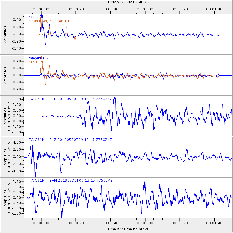
Signal To Noise
| Channel | StoN | STA | LTA |
| TA:G31M: :BHZ:20190530T09:13:15.775024Z | 1.2023023 | 6.126197E-7 | 5.0953884E-7 |
| TA:G31M: :BHN:20190530T09:13:15.775024Z | 2.8985765 | 3.9440843E-7 | 1.360697E-7 |
| TA:G31M: :BHE:20190530T09:13:15.775024Z | 3.3536527 | 5.181044E-7 | 1.5448957E-7 |
| Arrivals |
| Ps | 4.7 SECOND |
| PpPs | 12 SECOND |
| PsPs/PpSs | 17 SECOND |


