You are here: Home > Network List > TA - USArray Transportable Network (new EarthScope stations) Stations List
> Station HARP HAARP, Gakona, AK, USA > Earthquake Result Viewer
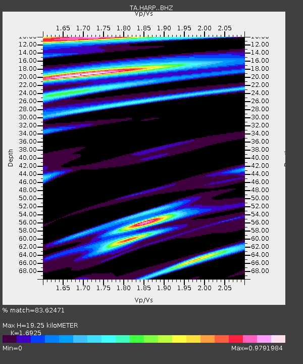
HARP HAARP, Gakona, AK, USA - Earthquake Result Viewer
| Earthquake location: |
El Salvador |
| Earthquake latitude/longitude: |
13.1/-89.4 |
| Earthquake time(UTC): |
2019/05/30 (150) 09:03:31 GMT |
| Earthquake Depth: |
10 km |
| Earthquake Magnitude: |
6.6 Mi |
| Earthquake Catalog/Contributor: |
NEIC PDE/at |
|
| Network: |
TA USArray Transportable Network (new EarthScope stations) |
| Station: |
HARP HAARP, Gakona, AK, USA |
| Lat/Lon: |
62.40 N/145.16 W |
| Elevation: |
581 m |
|
| Distance: |
62.9 deg |
| Az: |
334.373 deg |
| Baz: |
115.223 deg |
| Ray Param: |
0.059893243 |
| Estimated Moho Depth: |
19.25 km |
| Estimated Crust Vp/Vs: |
1.69 |
| Assumed Crust Vp: |
6.566 km/s |
| Estimated Crust Vs: |
3.88 km/s |
| Estimated Crust Poisson's Ratio: |
0.23 |
|
| Radial Match: |
83.62471 % |
| Radial Bump: |
400 |
| Transverse Match: |
79.69948 % |
| Transverse Bump: |
400 |
| SOD ConfigId: |
18369291 |
| Insert Time: |
2019-06-13 09:11:25.752 +0000 |
| GWidth: |
2.5 |
| Max Bumps: |
400 |
| Tol: |
0.001 |
|

Signal To Noise
| Channel | StoN | STA | LTA |
| TA:HARP: :BHZ:20190530T09:13:26.450012Z | 3.656566 | 1.2587248E-6 | 3.4423684E-7 |
| TA:HARP: :BHN:20190530T09:13:26.450012Z | 2.0650065 | 7.4997274E-7 | 3.631818E-7 |
| TA:HARP: :BHE:20190530T09:13:26.450012Z | 2.4672856 | 1.2725158E-6 | 5.157553E-7 |
| Arrivals |
| Ps | 2.1 SECOND |
| PpPs | 7.5 SECOND |
| PsPs/PpSs | 9.7 SECOND |


