You are here: Home > Network List > TS - TERRAscope (Southern California Seismic Network) Stations List
> Station GPO China Lake , California, USA > Earthquake Result Viewer
GPO China Lake , California, USA - Earthquake Result Viewer
*The percent match for this event was below the threshold and hence no stack was calculated.
| Earthquake location: |
Solomon Islands |
| Earthquake latitude/longitude: |
-6.7/154.9 |
| Earthquake time(UTC): |
1996/05/01 (122) 10:05:09 GMT |
| Earthquake Depth: |
33 km |
| Earthquake Magnitude: |
5.4 MB, 6.0 MS, 6.1 UNKNOWN, 6.0 MS |
| Earthquake Catalog/Contributor: |
WHDF/NEIC |
|
| Network: |
TS TERRAscope (Southern California Seismic Network) |
| Station: |
GPO China Lake , California, USA |
| Lat/Lon: |
35.65 N/117.66 W |
| Elevation: |
735 m |
|
| Distance: |
91.8 deg |
| Az: |
54.493 deg |
| Baz: |
263.065 deg |
| Ray Param: |
$rayparam |
*The percent match for this event was below the threshold and hence was not used in the summary stack. |
|
| Radial Match: |
71.68444 % |
| Radial Bump: |
400 |
| Transverse Match: |
85.64021 % |
| Transverse Bump: |
400 |
| SOD ConfigId: |
4480 |
| Insert Time: |
2010-02-26 14:14:35.489 +0000 |
| GWidth: |
2.5 |
| Max Bumps: |
400 |
| Tol: |
0.001 |
|
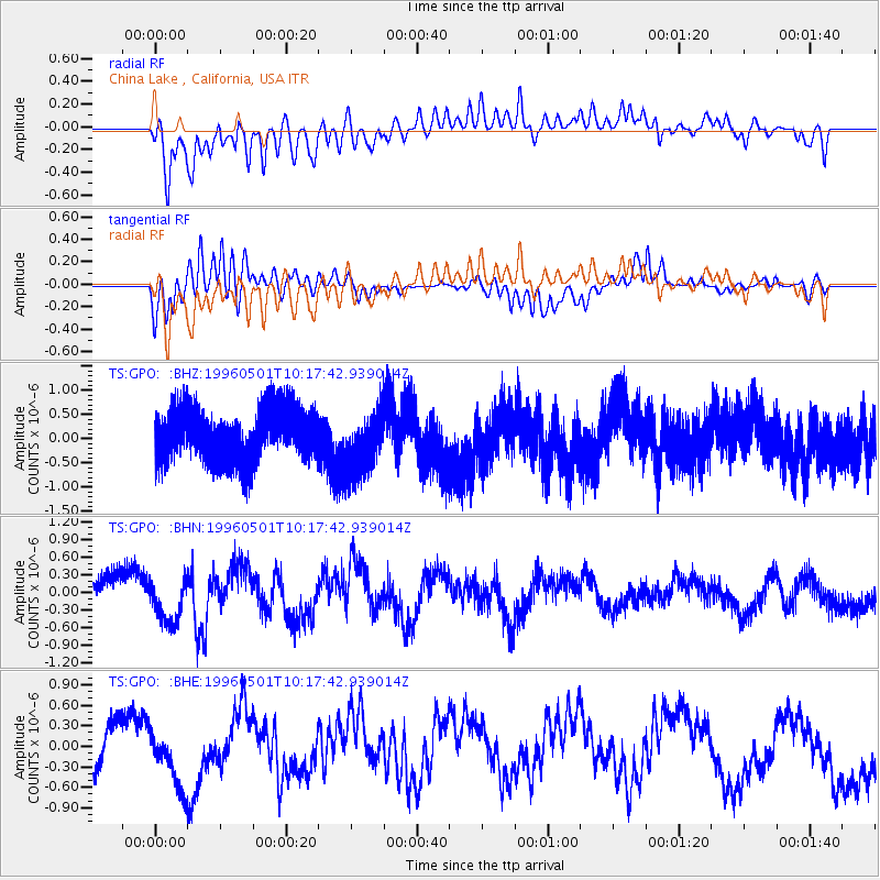
Signal To Noise
| Channel | StoN | STA | LTA |
| TS:GPO: :BHN:19960501T10:17:42.939014Z | 1.159711 | 3.8171203E-7 | 3.2914411E-7 |
| TS:GPO: :BHE:19960501T10:17:42.939014Z | 1.0139235 | 4.886702E-7 | 4.8195966E-7 |
| TS:GPO: :BHZ:19960501T10:17:42.939014Z | 1.1622227 | 6.339086E-7 | 5.454278E-7 |
| Arrivals |
| Ps | |
| PpPs | |
| PsPs/PpSs | |


