You are here: Home > Network List > IU - Global Seismograph Network (GSN - IRIS/USGS) Stations List
> Station PMG Port Moresby, New Guinea > Earthquake Result Viewer
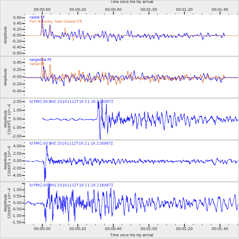
PMG Port Moresby, New Guinea - Earthquake Result Viewer
*The percent match for this event was below the threshold and hence no stack was calculated.
| Earthquake location: |
South Of Fiji Islands |
| Earthquake latitude/longitude: |
-25.0/178.7 |
| Earthquake time(UTC): |
2016/11/12 (317) 16:15:51 GMT |
| Earthquake Depth: |
565 km |
| Earthquake Magnitude: |
5.5 MB |
| Earthquake Catalog/Contributor: |
NEIC PDE/NEIC COMCAT |
|
| Network: |
IU Global Seismograph Network (GSN - IRIS/USGS) |
| Station: |
PMG Port Moresby, New Guinea |
| Lat/Lon: |
9.40 S/147.16 E |
| Elevation: |
90 m |
|
| Distance: |
33.7 deg |
| Az: |
291.76 deg |
| Baz: |
121.317 deg |
| Ray Param: |
$rayparam |
*The percent match for this event was below the threshold and hence was not used in the summary stack. |
|
| Radial Match: |
83.80942 % |
| Radial Bump: |
400 |
| Transverse Match: |
74.45277 % |
| Transverse Bump: |
400 |
| SOD ConfigId: |
1858631 |
| Insert Time: |
2016-11-28 15:45:32.768 +0000 |
| GWidth: |
2.5 |
| Max Bumps: |
400 |
| Tol: |
0.001 |
|
Signal To Noise
| Channel | StoN | STA | LTA |
| IU:PMG:00:BHZ:20161112T16:21:16.218987Z | 24.064007 | 2.0488865E-6 | 8.51432E-8 |
| IU:PMG:00:BH1:20161112T16:21:16.218987Z | 9.19935 | 5.964298E-7 | 6.4833905E-8 |
| IU:PMG:00:BH2:20161112T16:21:16.218987Z | 17.36622 | 1.0864668E-6 | 6.256207E-8 |
| Arrivals |
| Ps | |
| PpPs | |
| PsPs/PpSs | |


