You are here: Home > Network List > TA - USArray Transportable Network (new EarthScope stations) Stations List
> Station L18K Granite Mountain, AK, USA > Earthquake Result Viewer
L18K Granite Mountain, AK, USA - Earthquake Result Viewer
| Earthquake location: |
El Salvador |
| Earthquake latitude/longitude: |
13.1/-89.4 |
| Earthquake time(UTC): |
2019/05/30 (150) 09:03:31 GMT |
| Earthquake Depth: |
10 km |
| Earthquake Magnitude: |
6.6 Mi |
| Earthquake Catalog/Contributor: |
NEIC PDE/at |
|
| Network: |
TA USArray Transportable Network (new EarthScope stations) |
| Station: |
L18K Granite Mountain, AK, USA |
| Lat/Lon: |
62.22 N/156.69 W |
| Elevation: |
329 m |
|
| Distance: |
68.0 deg |
| Az: |
332.197 deg |
| Baz: |
104.114 deg |
| Ray Param: |
0.05661871 |
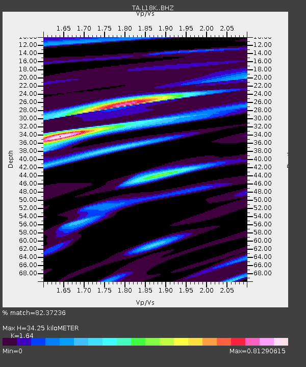
| Estimated Moho Depth: |
34.25 km |
| Estimated Crust Vp/Vs: |
1.64 |
| Assumed Crust Vp: |
6.182 km/s |
| Estimated Crust Vs: |
3.77 km/s |
| Estimated Crust Poisson's Ratio: |
0.20 |
|
| Radial Match: |
82.37236 % |
| Radial Bump: |
400 |
| Transverse Match: |
56.800232 % |
| Transverse Bump: |
400 |
| SOD ConfigId: |
18369291 |
| Insert Time: |
2019-06-13 09:11:42.620 +0000 |
| GWidth: |
2.5 |
| Max Bumps: |
400 |
| Tol: |
0.001 |
|

Signal To Noise
| Channel | StoN | STA | LTA |
| TA:L18K: :BHZ:20190530T09:13:58.775024Z | 2.467987 | 6.80525E-7 | 2.7574092E-7 |
| TA:L18K: :BHN:20190530T09:13:58.775024Z | 1.2565359 | 1.801314E-7 | 1.4335556E-7 |
| TA:L18K: :BHE:20190530T09:13:58.775024Z | 4.8854675 | 3.84195E-7 | 7.8640376E-8 |
| Arrivals |
| Ps | 3.7 SECOND |
| PpPs | 14 SECOND |
| PsPs/PpSs | 18 SECOND |


