You are here: Home > Network List > TA - USArray Transportable Network (new EarthScope stations) Stations List
> Station M18K Stony River, AK, USA > Earthquake Result Viewer
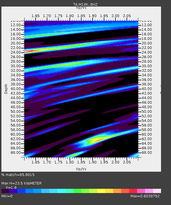
M18K Stony River, AK, USA - Earthquake Result Viewer
| Earthquake location: |
El Salvador |
| Earthquake latitude/longitude: |
13.1/-89.4 |
| Earthquake time(UTC): |
2019/05/30 (150) 09:03:31 GMT |
| Earthquake Depth: |
10 km |
| Earthquake Magnitude: |
6.6 Mi |
| Earthquake Catalog/Contributor: |
NEIC PDE/at |
|
| Network: |
TA USArray Transportable Network (new EarthScope stations) |
| Station: |
M18K Stony River, AK, USA |
| Lat/Lon: |
61.49 N/155.82 W |
| Elevation: |
289 m |
|
| Distance: |
67.4 deg |
| Az: |
331.541 deg |
| Baz: |
104.626 deg |
| Ray Param: |
0.056995858 |
| Estimated Moho Depth: |
23.5 km |
| Estimated Crust Vp/Vs: |
1.60 |
| Assumed Crust Vp: |
6.566 km/s |
| Estimated Crust Vs: |
4.104 km/s |
| Estimated Crust Poisson's Ratio: |
0.18 |
|
| Radial Match: |
85.9815 % |
| Radial Bump: |
400 |
| Transverse Match: |
77.211006 % |
| Transverse Bump: |
400 |
| SOD ConfigId: |
18369291 |
| Insert Time: |
2019-06-13 09:11:48.665 +0000 |
| GWidth: |
2.5 |
| Max Bumps: |
400 |
| Tol: |
0.001 |
|

Signal To Noise
| Channel | StoN | STA | LTA |
| TA:M18K: :BHZ:20190530T09:13:55.125Z | 2.5124354 | 6.464005E-7 | 2.5728045E-7 |
| TA:M18K: :BHN:20190530T09:13:55.125Z | 1.5484668 | 1.8475018E-7 | 1.1931168E-7 |
| TA:M18K: :BHE:20190530T09:13:55.125Z | 2.9067397 | 3.5014122E-7 | 1.2045841E-7 |
| Arrivals |
| Ps | 2.2 SECOND |
| PpPs | 8.9 SECOND |
| PsPs/PpSs | 11 SECOND |


