You are here: Home > Network List > TS - TERRAscope (Southern California Seismic Network) Stations List
> Station GPO China Lake , California, USA > Earthquake Result Viewer
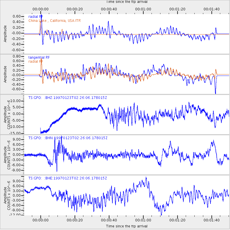
GPO China Lake , California, USA - Earthquake Result Viewer
*The percent match for this event was below the threshold and hence no stack was calculated.
| Earthquake location: |
Southern Bolivia |
| Earthquake latitude/longitude: |
-22.0/-65.7 |
| Earthquake time(UTC): |
1997/01/23 (023) 02:15:22 GMT |
| Earthquake Depth: |
276 km |
| Earthquake Magnitude: |
6.4 MB, 7.1 UNKNOWN, 7.1 MW |
| Earthquake Catalog/Contributor: |
WHDF/NEIC |
|
| Network: |
TS TERRAscope (Southern California Seismic Network) |
| Station: |
GPO China Lake , California, USA |
| Lat/Lon: |
35.65 N/117.66 W |
| Elevation: |
735 m |
|
| Distance: |
75.5 deg |
| Az: |
318.525 deg |
| Baz: |
131.002 deg |
| Ray Param: |
$rayparam |
*The percent match for this event was below the threshold and hence was not used in the summary stack. |
|
| Radial Match: |
61.90859 % |
| Radial Bump: |
400 |
| Transverse Match: |
31.110031 % |
| Transverse Bump: |
400 |
| SOD ConfigId: |
4480 |
| Insert Time: |
2010-02-26 14:14:35.891 +0000 |
| GWidth: |
2.5 |
| Max Bumps: |
400 |
| Tol: |
0.001 |
|
Signal To Noise
| Channel | StoN | STA | LTA |
| TS:GPO: :BHN:19970123T02:26:06.178015Z | 4.5252647 | 1.6499567E-6 | 3.6460997E-7 |
| TS:GPO: :BHE:19970123T02:26:06.178015Z | 1.6879011 | 7.449781E-6 | 4.413636E-6 |
| TS:GPO: :BHZ:19970123T02:26:06.178015Z | 1.1631528 | 7.731102E-6 | 6.6466782E-6 |
| Arrivals |
| Ps | |
| PpPs | |
| PsPs/PpSs | |


