You are here: Home > Network List > TA - USArray Transportable Network (new EarthScope stations) Stations List
> Station R31K City Hall, Gustavus, AK, USA > Earthquake Result Viewer
R31K City Hall, Gustavus, AK, USA - Earthquake Result Viewer
| Earthquake location: |
El Salvador |
| Earthquake latitude/longitude: |
13.1/-89.4 |
| Earthquake time(UTC): |
2019/05/30 (150) 09:03:31 GMT |
| Earthquake Depth: |
10 km |
| Earthquake Magnitude: |
6.6 Mi |
| Earthquake Catalog/Contributor: |
NEIC PDE/at |
|
| Network: |
TA USArray Transportable Network (new EarthScope stations) |
| Station: |
R31K City Hall, Gustavus, AK, USA |
| Lat/Lon: |
58.41 N/135.74 W |
| Elevation: |
15 m |
|
| Distance: |
56.9 deg |
| Az: |
332.956 deg |
| Baz: |
122.697 deg |
| Ray Param: |
0.06381816 |
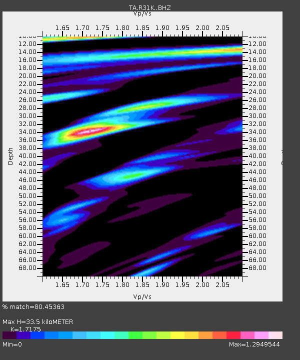
| Estimated Moho Depth: |
33.5 km |
| Estimated Crust Vp/Vs: |
1.72 |
| Assumed Crust Vp: |
6.566 km/s |
| Estimated Crust Vs: |
3.823 km/s |
| Estimated Crust Poisson's Ratio: |
0.24 |
|
| Radial Match: |
80.45363 % |
| Radial Bump: |
400 |
| Transverse Match: |
46.131165 % |
| Transverse Bump: |
400 |
| SOD ConfigId: |
18369291 |
| Insert Time: |
2019-06-13 09:12:13.933 +0000 |
| GWidth: |
2.5 |
| Max Bumps: |
400 |
| Tol: |
0.001 |
|
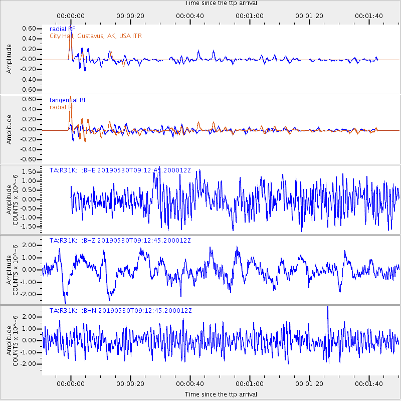
Signal To Noise
| Channel | StoN | STA | LTA |
| TA:R31K: :BHZ:20190530T09:12:45.200012Z | 3.1801107 | 8.485043E-7 | 2.66816E-7 |
| TA:R31K: :BHN:20190530T09:12:45.200012Z | 1.9001002 | 7.9488603E-7 | 4.18339E-7 |
| TA:R31K: :BHE:20190530T09:12:45.200012Z | 2.1863086 | 8.185934E-7 | 3.7441802E-7 |
| Arrivals |
| Ps | 3.9 SECOND |
| PpPs | 13 SECOND |
| PsPs/PpSs | 17 SECOND |


