You are here: Home > Network List > TA - USArray Transportable Network (new EarthScope stations) Stations List
> Station U35K Hyder, AK, USA > Earthquake Result Viewer
U35K Hyder, AK, USA - Earthquake Result Viewer
| Earthquake location: |
El Salvador |
| Earthquake latitude/longitude: |
13.1/-89.4 |
| Earthquake time(UTC): |
2019/05/30 (150) 09:03:31 GMT |
| Earthquake Depth: |
10 km |
| Earthquake Magnitude: |
6.6 Mi |
| Earthquake Catalog/Contributor: |
NEIC PDE/at |
|
| Network: |
TA USArray Transportable Network (new EarthScope stations) |
| Station: |
U35K Hyder, AK, USA |
| Lat/Lon: |
55.92 N/130.03 W |
| Elevation: |
17 m |
|
| Distance: |
52.9 deg |
| Az: |
332.634 deg |
| Baz: |
127.305 deg |
| Ray Param: |
0.06642906 |
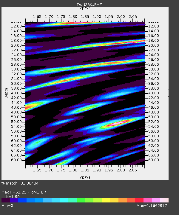
| Estimated Moho Depth: |
52.25 km |
| Estimated Crust Vp/Vs: |
1.99 |
| Assumed Crust Vp: |
6.545 km/s |
| Estimated Crust Vs: |
3.289 km/s |
| Estimated Crust Poisson's Ratio: |
0.33 |
|
| Radial Match: |
81.86484 % |
| Radial Bump: |
400 |
| Transverse Match: |
71.48053 % |
| Transverse Bump: |
400 |
| SOD ConfigId: |
18369291 |
| Insert Time: |
2019-06-13 09:12:18.701 +0000 |
| GWidth: |
2.5 |
| Max Bumps: |
400 |
| Tol: |
0.001 |
|

Signal To Noise
| Channel | StoN | STA | LTA |
| TA:U35K: :BHZ:20190530T09:12:16.424988Z | 9.106416 | 2.0706757E-6 | 2.2738648E-7 |
| TA:U35K: :BHN:20190530T09:12:16.424988Z | 4.3273807 | 7.8872455E-7 | 1.8226373E-7 |
| TA:U35K: :BHE:20190530T09:12:16.424988Z | 4.952908 | 1.0040877E-6 | 2.0272691E-7 |
| Arrivals |
| Ps | 8.3 SECOND |
| PpPs | 23 SECOND |
| PsPs/PpSs | 31 SECOND |


