You are here: Home > Network List > US - United States National Seismic Network Stations List
> Station LKWY Lake (Yellowstone--Lake), Wyoming, USA > Earthquake Result Viewer
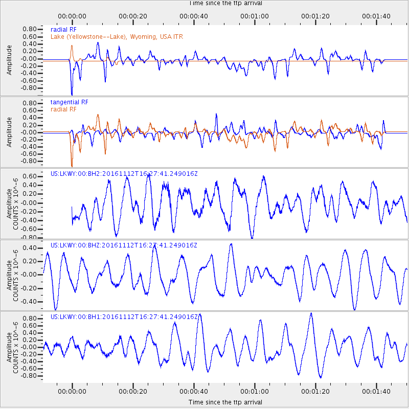
LKWY Lake (Yellowstone--Lake), Wyoming, USA - Earthquake Result Viewer
*The percent match for this event was below the threshold and hence no stack was calculated.
| Earthquake location: |
South Of Fiji Islands |
| Earthquake latitude/longitude: |
-25.0/178.7 |
| Earthquake time(UTC): |
2016/11/12 (317) 16:15:51 GMT |
| Earthquake Depth: |
565 km |
| Earthquake Magnitude: |
5.5 MB |
| Earthquake Catalog/Contributor: |
NEIC PDE/NEIC COMCAT |
|
| Network: |
US United States National Seismic Network |
| Station: |
LKWY Lake (Yellowstone--Lake), Wyoming, USA |
| Lat/Lon: |
44.57 N/110.40 W |
| Elevation: |
2424 m |
|
| Distance: |
94.7 deg |
| Az: |
42.678 deg |
| Baz: |
239.402 deg |
| Ray Param: |
$rayparam |
*The percent match for this event was below the threshold and hence was not used in the summary stack. |
|
| Radial Match: |
54.958626 % |
| Radial Bump: |
400 |
| Transverse Match: |
51.418797 % |
| Transverse Bump: |
400 |
| SOD ConfigId: |
1858631 |
| Insert Time: |
2016-11-28 15:46:27.052 +0000 |
| GWidth: |
2.5 |
| Max Bumps: |
400 |
| Tol: |
0.001 |
|
Signal To Noise
| Channel | StoN | STA | LTA |
| US:LKWY:00:BHZ:20161112T16:27:41.249016Z | 0.94014066 | 1.6228431E-7 | 1.7261705E-7 |
| US:LKWY:00:BH1:20161112T16:27:41.249016Z | 0.89126676 | 2.1024772E-7 | 2.3589764E-7 |
| US:LKWY:00:BH2:20161112T16:27:41.249016Z | 1.1435341 | 3.864003E-7 | 3.3790013E-7 |
| Arrivals |
| Ps | |
| PpPs | |
| PsPs/PpSs | |


