You are here: Home > Network List > UO - University of Oregon Regional Network Stations List
> Station VERN Vernonia Municipal Airport, Vernonia, OR, USA > Earthquake Result Viewer
VERN Vernonia Municipal Airport, Vernonia, OR, USA - Earthquake Result Viewer
| Earthquake location: |
El Salvador |
| Earthquake latitude/longitude: |
13.1/-89.4 |
| Earthquake time(UTC): |
2019/05/30 (150) 09:03:31 GMT |
| Earthquake Depth: |
10 km |
| Earthquake Magnitude: |
6.6 Mi |
| Earthquake Catalog/Contributor: |
NEIC PDE/at |
|
| Network: |
UO University of Oregon Regional Network |
| Station: |
VERN Vernonia Municipal Airport, Vernonia, OR, USA |
| Lat/Lon: |
45.85 N/123.25 W |
| Elevation: |
198 m |
|
| Distance: |
43.4 deg |
| Az: |
325.446 deg |
| Baz: |
127.76 deg |
| Ray Param: |
0.07258005 |
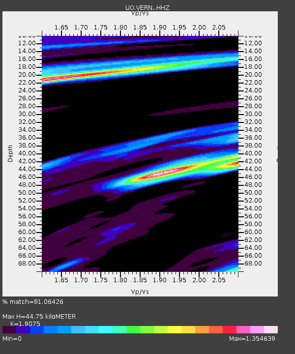
| Estimated Moho Depth: |
44.75 km |
| Estimated Crust Vp/Vs: |
1.91 |
| Assumed Crust Vp: |
6.566 km/s |
| Estimated Crust Vs: |
3.442 km/s |
| Estimated Crust Poisson's Ratio: |
0.31 |
|
| Radial Match: |
91.06426 % |
| Radial Bump: |
390 |
| Transverse Match: |
85.63005 % |
| Transverse Bump: |
400 |
| SOD ConfigId: |
18369291 |
| Insert Time: |
2019-06-13 09:12:37.536 +0000 |
| GWidth: |
2.5 |
| Max Bumps: |
400 |
| Tol: |
0.001 |
|

Signal To Noise
| Channel | StoN | STA | LTA |
| UO:VERN: :HHZ:20190530T09:11:02.720001Z | 19.180395 | 2.5322058E-6 | 1.3202052E-7 |
| UO:VERN: :HHN:20190530T09:11:02.720001Z | 6.9756975 | 8.681121E-7 | 1.2444806E-7 |
| UO:VERN: :HHE:20190530T09:11:02.720001Z | 12.872237 | 2.1894602E-6 | 1.7009165E-7 |
| Arrivals |
| Ps | 6.6 SECOND |
| PpPs | 19 SECOND |
| PsPs/PpSs | 25 SECOND |


