You are here: Home > Network List > US - United States National Seismic Network Stations List
> Station AGMN Agassiz National Wildlife Refuge, Minnesota, USA > Earthquake Result Viewer
AGMN Agassiz National Wildlife Refuge, Minnesota, USA - Earthquake Result Viewer
| Earthquake location: |
El Salvador |
| Earthquake latitude/longitude: |
13.1/-89.4 |
| Earthquake time(UTC): |
2019/05/30 (150) 09:03:31 GMT |
| Earthquake Depth: |
10 km |
| Earthquake Magnitude: |
6.6 Mi |
| Earthquake Catalog/Contributor: |
NEIC PDE/at |
|
| Network: |
US United States National Seismic Network |
| Station: |
AGMN Agassiz National Wildlife Refuge, Minnesota, USA |
| Lat/Lon: |
48.30 N/95.86 W |
| Elevation: |
351 m |
|
| Distance: |
35.5 deg |
| Az: |
352.517 deg |
| Baz: |
169.047 deg |
| Ray Param: |
0.07720132 |
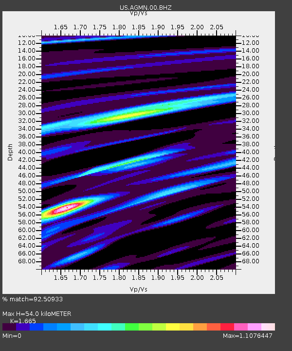
| Estimated Moho Depth: |
54.0 km |
| Estimated Crust Vp/Vs: |
1.66 |
| Assumed Crust Vp: |
6.419 km/s |
| Estimated Crust Vs: |
3.855 km/s |
| Estimated Crust Poisson's Ratio: |
0.22 |
|
| Radial Match: |
92.50933 % |
| Radial Bump: |
313 |
| Transverse Match: |
66.61317 % |
| Transverse Bump: |
400 |
| SOD ConfigId: |
18369291 |
| Insert Time: |
2019-06-13 09:12:39.559 +0000 |
| GWidth: |
2.5 |
| Max Bumps: |
400 |
| Tol: |
0.001 |
|
Signal To Noise
| Channel | StoN | STA | LTA |
| US:AGMN:00:BHZ:20190530T09:09:56.824005Z | 1.2249813 | 1.7386332E-6 | 1.419314E-6 |
| US:AGMN:00:BH1:20190530T09:09:56.824005Z | 4.52954 | 4.8833294E-6 | 1.0781071E-6 |
| US:AGMN:00:BH2:20190530T09:09:56.824005Z | 21.01906 | 3.8721605E-6 | 1.8422139E-7 |
| Arrivals |
| Ps | 6.1 SECOND |
| PpPs | 21 SECOND |
| PsPs/PpSs | 27 SECOND |


