You are here: Home > Network List > TA - USArray Transportable Network (new EarthScope stations) Stations List
> Station Y21A Point of Rocks Canyon, Magdalena, NM, USA > Earthquake Result Viewer
Y21A Point of Rocks Canyon, Magdalena, NM, USA - Earthquake Result Viewer
| Earthquake location: |
Easter Island Region |
| Earthquake latitude/longitude: |
-28.5/-112.8 |
| Earthquake time(UTC): |
2008/08/19 (232) 10:58:00 GMT |
| Earthquake Depth: |
9.0 km |
| Earthquake Magnitude: |
5.5 MB, 5.3 MS, 5.7 MW, 5.7 MW |
| Earthquake Catalog/Contributor: |
WHDF/NEIC |
|
| Network: |
TA USArray Transportable Network (new EarthScope stations) |
| Station: |
Y21A Point of Rocks Canyon, Magdalena, NM, USA |
| Lat/Lon: |
34.01 N/107.67 W |
| Elevation: |
2168 m |
|
| Distance: |
62.4 deg |
| Az: |
4.843 deg |
| Baz: |
185.13 deg |
| Ray Param: |
0.06024929 |
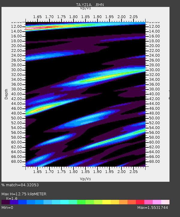
| Estimated Moho Depth: |
12.75 km |
| Estimated Crust Vp/Vs: |
1.60 |
| Assumed Crust Vp: |
6.502 km/s |
| Estimated Crust Vs: |
4.063 km/s |
| Estimated Crust Poisson's Ratio: |
0.18 |
|
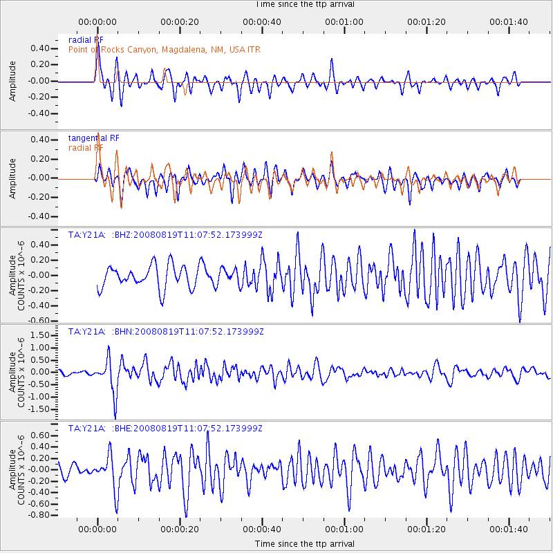
| Radial Match: |
84.32053 % |
| Radial Bump: |
400 |
| Transverse Match: |
73.14205 % |
| Transverse Bump: |
400 |
| SOD ConfigId: |
2504 |
| Insert Time: |
2010-03-06 23:07:30.974 +0000 |
| GWidth: |
2.5 |
| Max Bumps: |
400 |
| Tol: |
0.001 |
|
Signal To Noise
| Channel | StoN | STA | LTA |
| TA:Y21A: :BHN:20080819T11:07:52.173999Z | 9.263581 | 7.051879E-7 | 7.6124756E-8 |
| TA:Y21A: :BHE:20080819T11:07:52.173999Z | 3.351364 | 3.0377564E-7 | 9.0642395E-8 |
| TA:Y21A: :BHZ:20080819T11:07:52.173999Z | 0.67825085 | 9.8509155E-8 | 1.4524E-7 |
| Arrivals |
| Ps | 1.2 SECOND |
| PpPs | 4.8 SECOND |
| PsPs/PpSs | 6.1 SECOND |


