You are here: Home > Network List > UU - University of Utah Regional Network Stations List
> Station FOR1 Milford Southwest, UT, USA > Earthquake Result Viewer
FOR1 Milford Southwest, UT, USA - Earthquake Result Viewer
| Earthquake location: |
El Salvador |
| Earthquake latitude/longitude: |
13.1/-89.4 |
| Earthquake time(UTC): |
2019/05/30 (150) 09:03:31 GMT |
| Earthquake Depth: |
10 km |
| Earthquake Magnitude: |
6.6 Mi |
| Earthquake Catalog/Contributor: |
NEIC PDE/at |
|
| Network: |
UU University of Utah Regional Network |
| Station: |
FOR1 Milford Southwest, UT, USA |
| Lat/Lon: |
38.37 N/113.09 W |
| Elevation: |
1642 m |
|
| Distance: |
32.8 deg |
| Az: |
324.274 deg |
| Baz: |
133.641 deg |
| Ray Param: |
0.078495726 |
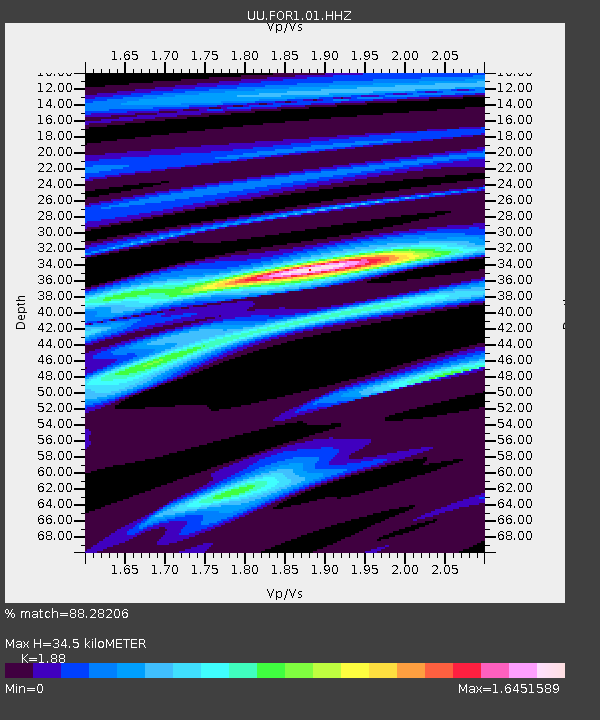
| Estimated Moho Depth: |
34.5 km |
| Estimated Crust Vp/Vs: |
1.88 |
| Assumed Crust Vp: |
6.276 km/s |
| Estimated Crust Vs: |
3.338 km/s |
| Estimated Crust Poisson's Ratio: |
0.30 |
|
| Radial Match: |
88.28206 % |
| Radial Bump: |
356 |
| Transverse Match: |
66.74962 % |
| Transverse Bump: |
395 |
| SOD ConfigId: |
18369291 |
| Insert Time: |
2019-06-13 09:12:58.973 +0000 |
| GWidth: |
2.5 |
| Max Bumps: |
400 |
| Tol: |
0.001 |
|

Signal To Noise
| Channel | StoN | STA | LTA |
| UU:FOR1:01:HHZ:20190530T09:09:33.670013Z | 9.99846 | 3.6253223E-8 | 3.6258807E-9 |
| UU:FOR1:01:HHN:20190530T09:09:33.670013Z | 6.0029755 | 1.5142982E-8 | 2.5225795E-9 |
| UU:FOR1:01:HHE:20190530T09:09:33.670013Z | 13.181232 | 1.744925E-8 | 1.323795E-9 |
| Arrivals |
| Ps | 5.2 SECOND |
| PpPs | 15 SECOND |
| PsPs/PpSs | 20 SECOND |


