You are here: Home > Network List > UU - University of Utah Regional Network Stations List
> Station HMU Henry Mountain, UT, USA > Earthquake Result Viewer
HMU Henry Mountain, UT, USA - Earthquake Result Viewer
| Earthquake location: |
El Salvador |
| Earthquake latitude/longitude: |
13.1/-89.4 |
| Earthquake time(UTC): |
2019/05/30 (150) 09:03:31 GMT |
| Earthquake Depth: |
10 km |
| Earthquake Magnitude: |
6.6 Mi |
| Earthquake Catalog/Contributor: |
NEIC PDE/at |
|
| Network: |
UU University of Utah Regional Network |
| Station: |
HMU Henry Mountain, UT, USA |
| Lat/Lon: |
37.94 N/110.74 W |
| Elevation: |
2430 m |
|
| Distance: |
31.2 deg |
| Az: |
326.183 deg |
| Baz: |
136.708 deg |
| Ray Param: |
0.07913386 |
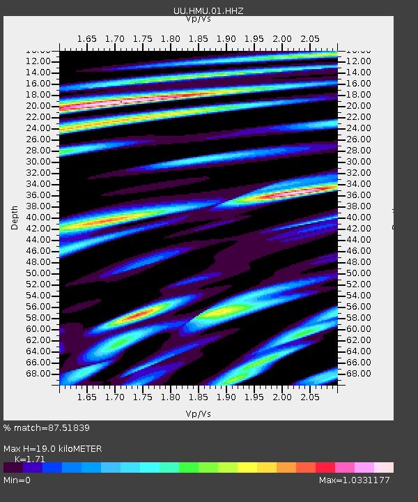
| Estimated Moho Depth: |
19.0 km |
| Estimated Crust Vp/Vs: |
1.71 |
| Assumed Crust Vp: |
6.247 km/s |
| Estimated Crust Vs: |
3.653 km/s |
| Estimated Crust Poisson's Ratio: |
0.24 |
|
| Radial Match: |
87.51839 % |
| Radial Bump: |
400 |
| Transverse Match: |
75.8883 % |
| Transverse Bump: |
400 |
| SOD ConfigId: |
18369291 |
| Insert Time: |
2019-06-13 09:13:02.259 +0000 |
| GWidth: |
2.5 |
| Max Bumps: |
400 |
| Tol: |
0.001 |
|

Signal To Noise
| Channel | StoN | STA | LTA |
| UU:HMU:01:HHZ:20190530T09:09:19.558014Z | 24.570642 | 6.2064856E-8 | 2.5259759E-9 |
| UU:HMU:01:HHN:20190530T09:09:19.558014Z | 23.480736 | 3.7496825E-8 | 1.5969186E-9 |
| UU:HMU:01:HHE:20190530T09:09:19.558014Z | 16.387367 | 4.331532E-8 | 2.643214E-9 |
| Arrivals |
| Ps | 2.3 SECOND |
| PpPs | 7.6 SECOND |
| PsPs/PpSs | 10.0 SECOND |


