You are here: Home > Network List > TA - USArray Transportable Network (new EarthScope stations) Stations List
> Station Y21A Point of Rocks Canyon, Magdalena, NM, USA > Earthquake Result Viewer
Y21A Point of Rocks Canyon, Magdalena, NM, USA - Earthquake Result Viewer
| Earthquake location: |
Santa Cruz Islands Region |
| Earthquake latitude/longitude: |
-11.0/164.5 |
| Earthquake time(UTC): |
2008/07/19 (201) 09:27:01 GMT |
| Earthquake Depth: |
11 km |
| Earthquake Magnitude: |
6.1 MB, 6.4 MS, 6.6 MW, 6.6 MW |
| Earthquake Catalog/Contributor: |
WHDF/NEIC |
|
| Network: |
TA USArray Transportable Network (new EarthScope stations) |
| Station: |
Y21A Point of Rocks Canyon, Magdalena, NM, USA |
| Lat/Lon: |
34.01 N/107.67 W |
| Elevation: |
2168 m |
|
| Distance: |
94.3 deg |
| Az: |
56.351 deg |
| Baz: |
259.675 deg |
| Ray Param: |
0.04107369 |
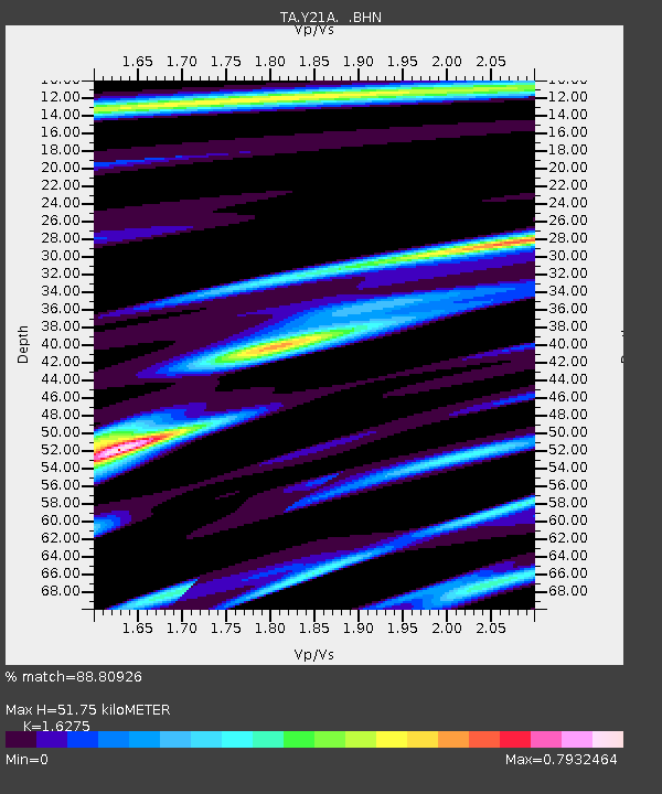
| Estimated Moho Depth: |
51.75 km |
| Estimated Crust Vp/Vs: |
1.63 |
| Assumed Crust Vp: |
6.502 km/s |
| Estimated Crust Vs: |
3.995 km/s |
| Estimated Crust Poisson's Ratio: |
0.20 |
|
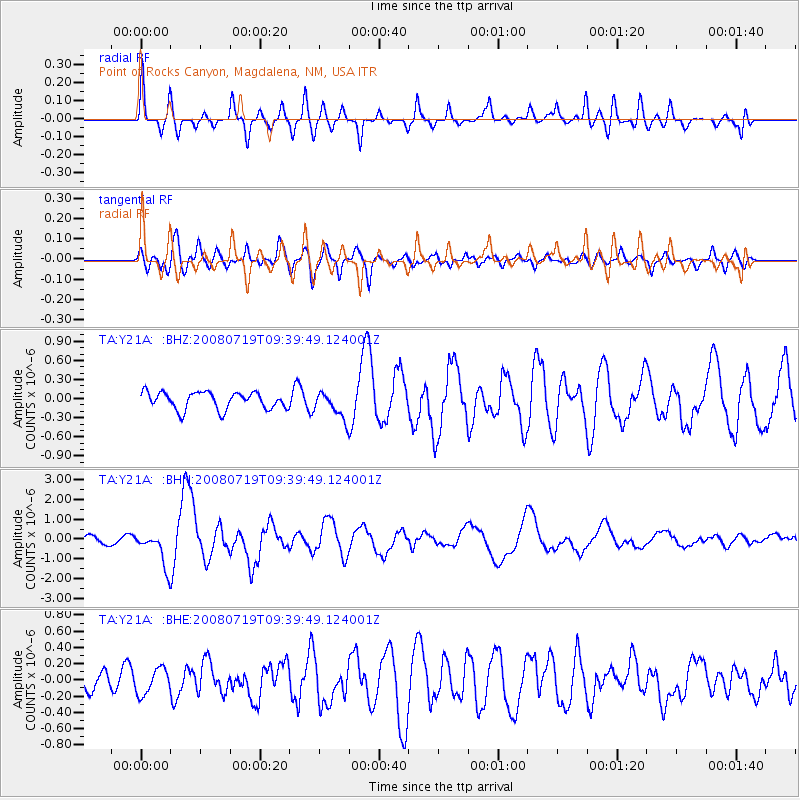
| Radial Match: |
88.80926 % |
| Radial Bump: |
400 |
| Transverse Match: |
79.89655 % |
| Transverse Bump: |
400 |
| SOD ConfigId: |
2658 |
| Insert Time: |
2010-03-06 23:07:48.803 +0000 |
| GWidth: |
2.5 |
| Max Bumps: |
400 |
| Tol: |
0.001 |
|
Signal To Noise
| Channel | StoN | STA | LTA |
| TA:Y21A: :BHN:20080719T09:39:49.124001Z | 5.169543 | 8.7202267E-7 | 1.6868468E-7 |
| TA:Y21A: :BHE:20080719T09:39:49.124001Z | 1.6528872 | 1.5961048E-7 | 9.656465E-8 |
| TA:Y21A: :BHZ:20080719T09:39:49.124001Z | 1.5861857 | 2.1317116E-7 | 1.3439231E-7 |
| Arrivals |
| Ps | 5.1 SECOND |
| PpPs | 20 SECOND |
| PsPs/PpSs | 26 SECOND |


