You are here: Home > Network List > TA - USArray Transportable Network (new EarthScope stations) Stations List
> Station Y21A Point of Rocks Canyon, Magdalena, NM, USA > Earthquake Result Viewer
Y21A Point of Rocks Canyon, Magdalena, NM, USA - Earthquake Result Viewer
| Earthquake location: |
Peru-Bolivia Border Region |
| Earthquake latitude/longitude: |
-15.6/-69.3 |
| Earthquake time(UTC): |
2009/09/30 (273) 19:03:17 GMT |
| Earthquake Depth: |
255 km |
| Earthquake Magnitude: |
5.9 MB, 5.8 MW |
| Earthquake Catalog/Contributor: |
WHDF/NEIC |
|
| Network: |
TA USArray Transportable Network (new EarthScope stations) |
| Station: |
Y21A Point of Rocks Canyon, Magdalena, NM, USA |
| Lat/Lon: |
34.01 N/107.67 W |
| Elevation: |
2168 m |
|
| Distance: |
61.4 deg |
| Az: |
324.008 deg |
| Baz: |
137.01 deg |
| Ray Param: |
0.06009952 |
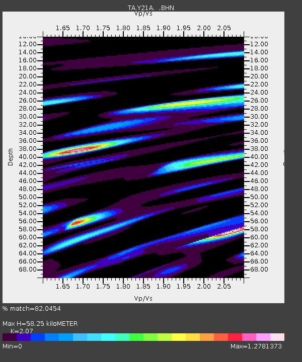
| Estimated Moho Depth: |
58.25 km |
| Estimated Crust Vp/Vs: |
2.07 |
| Assumed Crust Vp: |
6.502 km/s |
| Estimated Crust Vs: |
3.141 km/s |
| Estimated Crust Poisson's Ratio: |
0.35 |
|
| Radial Match: |
82.0454 % |
| Radial Bump: |
400 |
| Transverse Match: |
72.707405 % |
| Transverse Bump: |
400 |
| SOD ConfigId: |
2622 |
| Insert Time: |
2010-03-06 23:08:10.147 +0000 |
| GWidth: |
2.5 |
| Max Bumps: |
400 |
| Tol: |
0.001 |
|
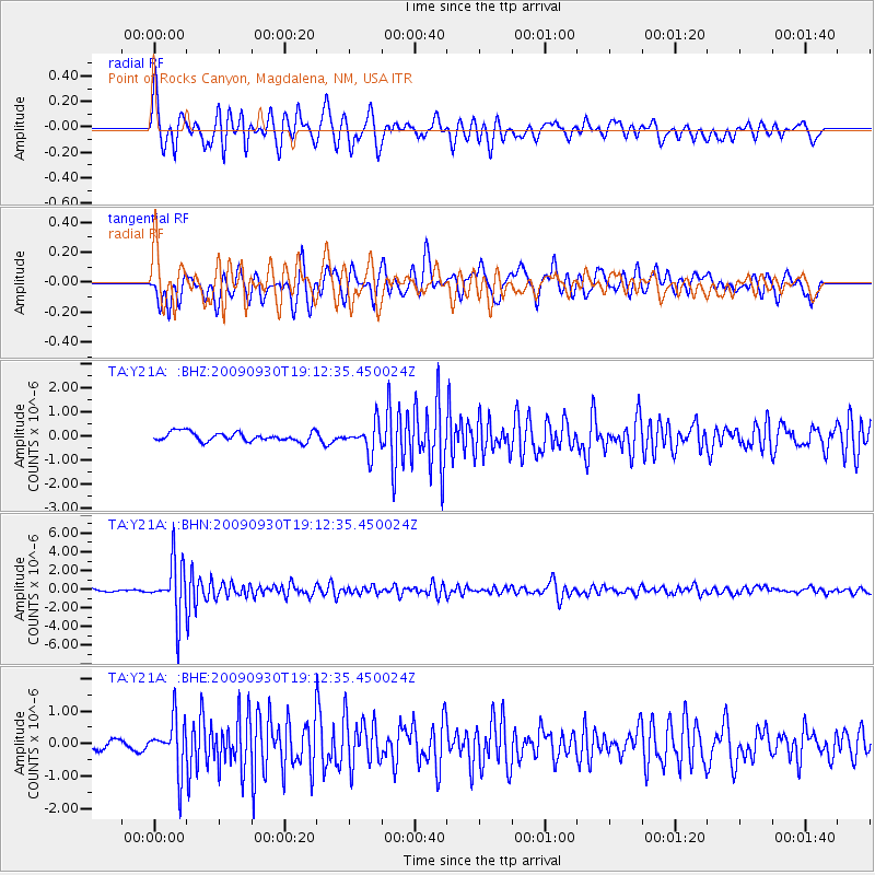
Signal To Noise
| Channel | StoN | STA | LTA |
| TA:Y21A: :BHN:20090930T19:12:35.450024Z | 21.0765 | 2.8694494E-6 | 1.361445E-7 |
| TA:Y21A: :BHE:20090930T19:12:35.450024Z | 6.207172 | 7.9058424E-7 | 1.2736625E-7 |
| TA:Y21A: :BHZ:20090930T19:12:35.450024Z | 3.1059287 | 5.8811946E-7 | 1.8935383E-7 |
| Arrivals |
| Ps | 10.0 SECOND |
| PpPs | 26 SECOND |
| PsPs/PpSs | 36 SECOND |


