You are here: Home > Network List > TA - USArray Transportable Network (new EarthScope stations) Stations List
> Station Y21A Point of Rocks Canyon, Magdalena, NM, USA > Earthquake Result Viewer
Y21A Point of Rocks Canyon, Magdalena, NM, USA - Earthquake Result Viewer
| Earthquake location: |
Santa Cruz Islands |
| Earthquake latitude/longitude: |
-12.4/166.1 |
| Earthquake time(UTC): |
2009/10/07 (280) 22:50:15 GMT |
| Earthquake Depth: |
21 km |
| Earthquake Magnitude: |
5.8 MB |
| Earthquake Catalog/Contributor: |
WHDF/NEIC |
|
| Network: |
TA USArray Transportable Network (new EarthScope stations) |
| Station: |
Y21A Point of Rocks Canyon, Magdalena, NM, USA |
| Lat/Lon: |
34.01 N/107.67 W |
| Elevation: |
2168 m |
|
| Distance: |
93.8 deg |
| Az: |
56.169 deg |
| Baz: |
257.689 deg |
| Ray Param: |
0.041193355 |
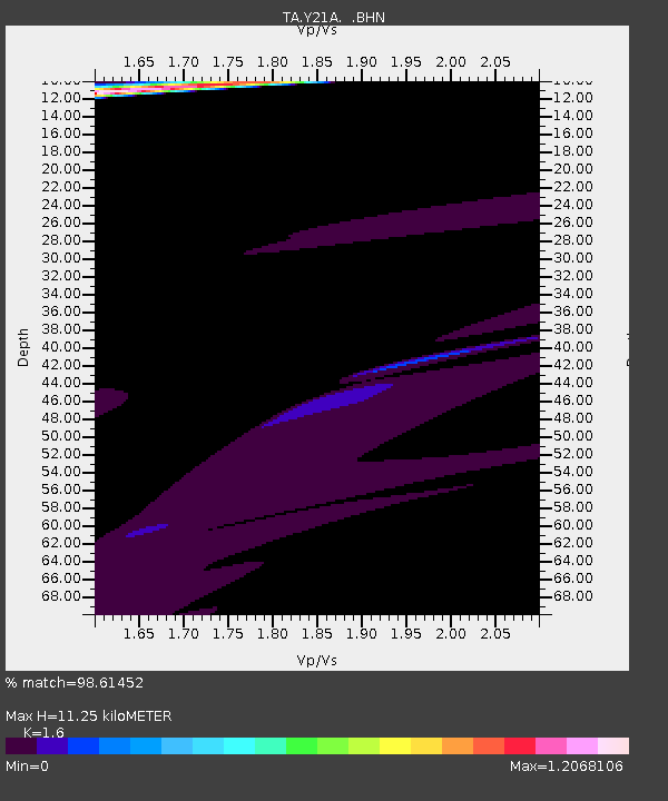
| Estimated Moho Depth: |
11.25 km |
| Estimated Crust Vp/Vs: |
1.60 |
| Assumed Crust Vp: |
6.502 km/s |
| Estimated Crust Vs: |
4.063 km/s |
| Estimated Crust Poisson's Ratio: |
0.18 |
|
| Radial Match: |
98.61452 % |
| Radial Bump: |
264 |
| Transverse Match: |
92.3121 % |
| Transverse Bump: |
180 |
| SOD ConfigId: |
2622 |
| Insert Time: |
2010-03-06 23:08:15.001 +0000 |
| GWidth: |
2.5 |
| Max Bumps: |
400 |
| Tol: |
0.001 |
|
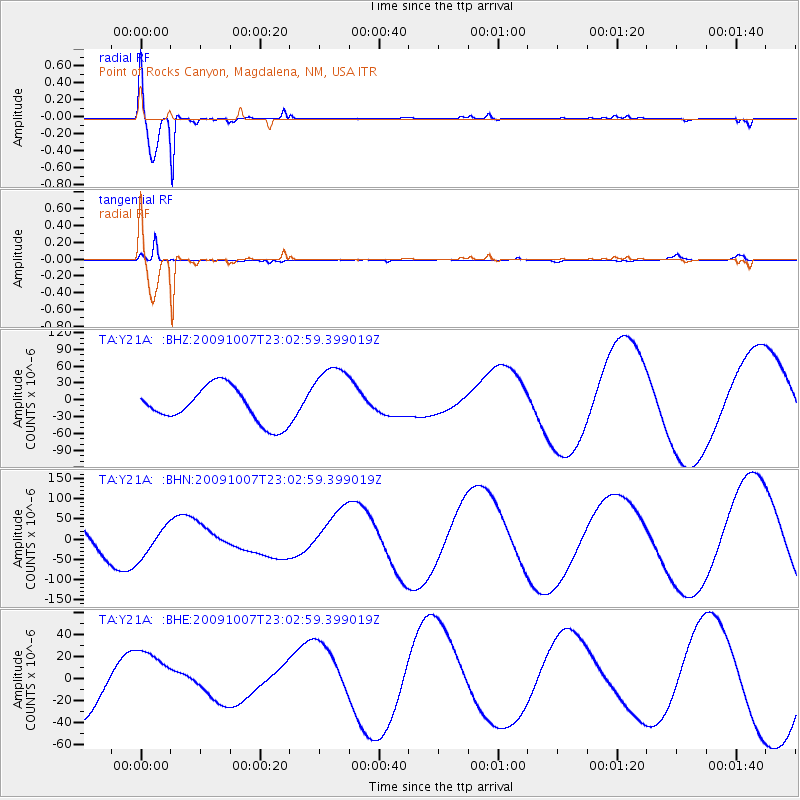
Signal To Noise
| Channel | StoN | STA | LTA |
| TA:Y21A: :BHN:20091007T23:02:59.399019Z | 1.2478728 | 3.7839716E-5 | 3.0323376E-5 |
| TA:Y21A: :BHE:20091007T23:02:59.399019Z | 1.3426673 | 2.5784337E-5 | 1.9203817E-5 |
| TA:Y21A: :BHZ:20091007T23:02:59.399019Z | 1.9364313 | 6.110241E-5 | 3.1554133E-5 |
| Arrivals |
| Ps | 1.1 SECOND |
| PpPs | 4.4 SECOND |
| PsPs/PpSs | 5.5 SECOND |


