You are here: Home > Network List > TA - USArray Transportable Network (new EarthScope stations) Stations List
> Station Y21A Point of Rocks Canyon, Magdalena, NM, USA > Earthquake Result Viewer
Y21A Point of Rocks Canyon, Magdalena, NM, USA - Earthquake Result Viewer
| Earthquake location: |
Kodiak Island Region, Alaska |
| Earthquake latitude/longitude: |
56.5/-152.7 |
| Earthquake time(UTC): |
2009/03/30 (089) 07:13:07 GMT |
| Earthquake Depth: |
21 km |
| Earthquake Magnitude: |
5.9 MB, 5.9 MS, 5.9 MW, 5.9 MW |
| Earthquake Catalog/Contributor: |
WHDF/NEIC |
|
| Network: |
TA USArray Transportable Network (new EarthScope stations) |
| Station: |
Y21A Point of Rocks Canyon, Magdalena, NM, USA |
| Lat/Lon: |
34.01 N/107.67 W |
| Elevation: |
2168 m |
|
| Distance: |
38.0 deg |
| Az: |
107.03 deg |
| Baz: |
320.395 deg |
| Ray Param: |
0.07581172 |
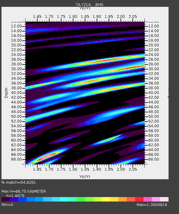
| Estimated Moho Depth: |
66.75 km |
| Estimated Crust Vp/Vs: |
1.69 |
| Assumed Crust Vp: |
6.502 km/s |
| Estimated Crust Vs: |
3.853 km/s |
| Estimated Crust Poisson's Ratio: |
0.23 |
|
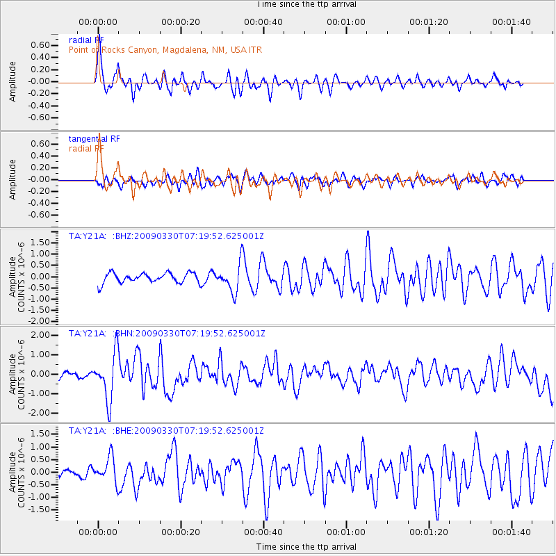
| Radial Match: |
84.6281 % |
| Radial Bump: |
400 |
| Transverse Match: |
66.83209 % |
| Transverse Bump: |
400 |
| SOD ConfigId: |
2658 |
| Insert Time: |
2010-03-06 23:08:35.506 +0000 |
| GWidth: |
2.5 |
| Max Bumps: |
400 |
| Tol: |
0.001 |
|
Signal To Noise
| Channel | StoN | STA | LTA |
| TA:Y21A: :BHN:20090330T07:19:52.625001Z | 8.956434 | 1.2498983E-6 | 1.3955312E-7 |
| TA:Y21A: :BHE:20090330T07:19:52.625001Z | 2.445137 | 5.246948E-7 | 2.1458708E-7 |
| TA:Y21A: :BHZ:20090330T07:19:52.625001Z | 2.9048655 | 6.4332477E-7 | 2.2146457E-7 |
| Arrivals |
| Ps | 7.6 SECOND |
| PpPs | 26 SECOND |
| PsPs/PpSs | 33 SECOND |


