You are here: Home > Network List > TA - USArray Transportable Network (new EarthScope stations) Stations List
> Station Y21A Point of Rocks Canyon, Magdalena, NM, USA > Earthquake Result Viewer
Y21A Point of Rocks Canyon, Magdalena, NM, USA - Earthquake Result Viewer
| Earthquake location: |
Kodiak Island Region, Alaska |
| Earthquake latitude/longitude: |
56.4/-152.4 |
| Earthquake time(UTC): |
2009/05/16 (136) 18:22:25 GMT |
| Earthquake Depth: |
9.7 km |
| Earthquake Magnitude: |
5.9 MS, 5.4 MB, 5.9 MW, 5.8 MW |
| Earthquake Catalog/Contributor: |
WHDF/NEIC |
|
| Network: |
TA USArray Transportable Network (new EarthScope stations) |
| Station: |
Y21A Point of Rocks Canyon, Magdalena, NM, USA |
| Lat/Lon: |
34.01 N/107.67 W |
| Elevation: |
2168 m |
|
| Distance: |
37.8 deg |
| Az: |
107.222 deg |
| Baz: |
320.305 deg |
| Ray Param: |
0.075957604 |
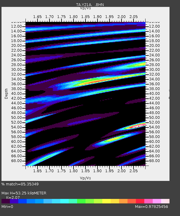
| Estimated Moho Depth: |
53.25 km |
| Estimated Crust Vp/Vs: |
2.07 |
| Assumed Crust Vp: |
6.502 km/s |
| Estimated Crust Vs: |
3.141 km/s |
| Estimated Crust Poisson's Ratio: |
0.35 |
|
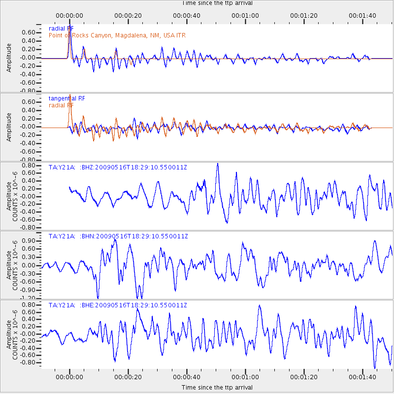
| Radial Match: |
85.35349 % |
| Radial Bump: |
400 |
| Transverse Match: |
57.695026 % |
| Transverse Bump: |
400 |
| SOD ConfigId: |
2760 |
| Insert Time: |
2010-03-06 23:08:48.904 +0000 |
| GWidth: |
2.5 |
| Max Bumps: |
400 |
| Tol: |
0.001 |
|
Signal To Noise
| Channel | StoN | STA | LTA |
| TA:Y21A: :BHN:20090516T18:29:10.550011Z | 1.9547551 | 1.51151E-7 | 7.732478E-8 |
| TA:Y21A: :BHE:20090516T18:29:10.550011Z | 1.0172614 | 1.3952645E-7 | 1.3715889E-7 |
| TA:Y21A: :BHZ:20090516T18:29:10.550011Z | 1.7967465 | 2.3367392E-7 | 1.300539E-7 |
| Arrivals |
| Ps | 9.3 SECOND |
| PpPs | 24 SECOND |
| PsPs/PpSs | 33 SECOND |


