You are here: Home > Network List > TA - USArray Transportable Network (new EarthScope stations) Stations List
> Station Y21A Point of Rocks Canyon, Magdalena, NM, USA > Earthquake Result Viewer
Y21A Point of Rocks Canyon, Magdalena, NM, USA - Earthquake Result Viewer
| Earthquake location: |
Andreanof Islands, Aleutian Is. |
| Earthquake latitude/longitude: |
51.9/-179.2 |
| Earthquake time(UTC): |
2008/04/16 (107) 05:54:19 GMT |
| Earthquake Depth: |
13 km |
| Earthquake Magnitude: |
6.1 MB, 6.5 MS, 6.6 MW, 6.6 MW |
| Earthquake Catalog/Contributor: |
WHDF/NEIC |
|
| Network: |
TA USArray Transportable Network (new EarthScope stations) |
| Station: |
Y21A Point of Rocks Canyon, Magdalena, NM, USA |
| Lat/Lon: |
34.01 N/107.67 W |
| Elevation: |
2168 m |
|
| Distance: |
53.1 deg |
| Az: |
80.049 deg |
| Baz: |
312.691 deg |
| Ray Param: |
0.06631484 |
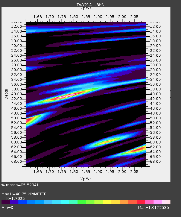
| Estimated Moho Depth: |
40.75 km |
| Estimated Crust Vp/Vs: |
1.76 |
| Assumed Crust Vp: |
6.502 km/s |
| Estimated Crust Vs: |
3.689 km/s |
| Estimated Crust Poisson's Ratio: |
0.26 |
|
| Radial Match: |
85.52841 % |
| Radial Bump: |
400 |
| Transverse Match: |
81.695564 % |
| Transverse Bump: |
400 |
| SOD ConfigId: |
2504 |
| Insert Time: |
2010-03-06 23:08:50.801 +0000 |
| GWidth: |
2.5 |
| Max Bumps: |
400 |
| Tol: |
0.001 |
|
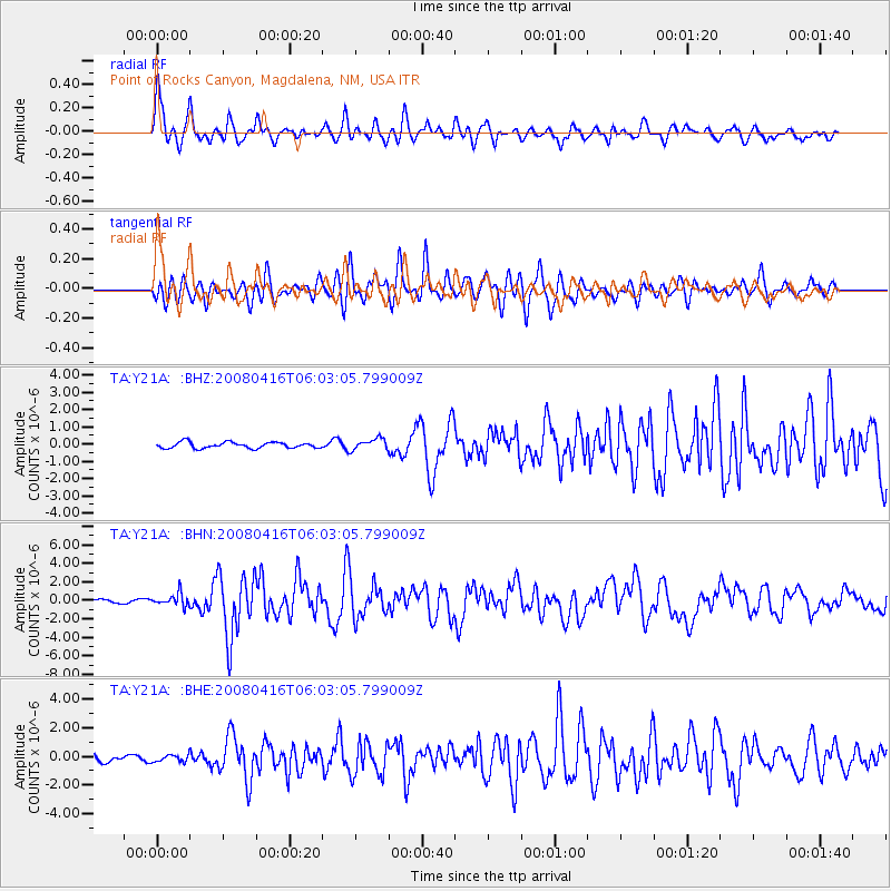
Signal To Noise
| Channel | StoN | STA | LTA |
| TA:Y21A: :BHN:20080416T06:03:05.799009Z | 5.3453083 | 6.805681E-7 | 1.2732065E-7 |
| TA:Y21A: :BHE:20080416T06:03:05.799009Z | 0.97987443 | 2.4515953E-7 | 2.5019483E-7 |
| TA:Y21A: :BHZ:20080416T06:03:05.799009Z | 1.8940679 | 3.2613568E-7 | 1.7218795E-7 |
| Arrivals |
| Ps | 5.1 SECOND |
| PpPs | 16 SECOND |
| PsPs/PpSs | 21 SECOND |


