You are here: Home > Network List > TS - TERRAscope (Southern California Seismic Network) Stations List
> Station GPO China Lake , California, USA > Earthquake Result Viewer
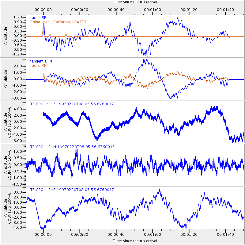
GPO China Lake , California, USA - Earthquake Result Viewer
*The percent match for this event was below the threshold and hence no stack was calculated.
| Earthquake location: |
Hokkaido, Japan Region |
| Earthquake latitude/longitude: |
41.9/142.7 |
| Earthquake time(UTC): |
1997/02/20 (051) 07:54:58 GMT |
| Earthquake Depth: |
33 km |
| Earthquake Magnitude: |
5.4 MB, 5.5 MS, 6.0 UNKNOWN, 6.0 MW |
| Earthquake Catalog/Contributor: |
WHDF/NEIC |
|
| Network: |
TS TERRAscope (Southern California Seismic Network) |
| Station: |
GPO China Lake , California, USA |
| Lat/Lon: |
35.65 N/117.66 W |
| Elevation: |
735 m |
|
| Distance: |
73.5 deg |
| Az: |
56.89 deg |
| Baz: |
309.801 deg |
| Ray Param: |
$rayparam |
*The percent match for this event was below the threshold and hence was not used in the summary stack. |
|
| Radial Match: |
40.029037 % |
| Radial Bump: |
400 |
| Transverse Match: |
24.420734 % |
| Transverse Bump: |
400 |
| SOD ConfigId: |
4480 |
| Insert Time: |
2010-02-26 14:14:37.595 +0000 |
| GWidth: |
2.5 |
| Max Bumps: |
400 |
| Tol: |
0.001 |
|
Signal To Noise
| Channel | StoN | STA | LTA |
| TS:GPO: :BHN:19970220T08:05:56.676001Z | 1.6965363 | 3.718515E-7 | 2.1918275E-7 |
| TS:GPO: :BHE:19970220T08:05:56.676001Z | 4.5055 | 4.0937534E-6 | 9.0861244E-7 |
| TS:GPO: :BHZ:19970220T08:05:56.676001Z | 4.231776 | 4.9626433E-6 | 1.1727092E-6 |
| Arrivals |
| Ps | |
| PpPs | |
| PsPs/PpSs | |


