You are here: Home > Network List > TA - USArray Transportable Network (new EarthScope stations) Stations List
> Station Y21A Point of Rocks Canyon, Magdalena, NM, USA > Earthquake Result Viewer
Y21A Point of Rocks Canyon, Magdalena, NM, USA - Earthquake Result Viewer
| Earthquake location: |
Trinidad |
| Earthquake latitude/longitude: |
10.3/-60.4 |
| Earthquake time(UTC): |
2008/07/03 (185) 06:34:53 GMT |
| Earthquake Depth: |
34 km |
| Earthquake Magnitude: |
5.7 MB, 5.5 MS, 5.8 MW, 5.7 MW |
| Earthquake Catalog/Contributor: |
WHDF/NEIC |
|
| Network: |
TA USArray Transportable Network (new EarthScope stations) |
| Station: |
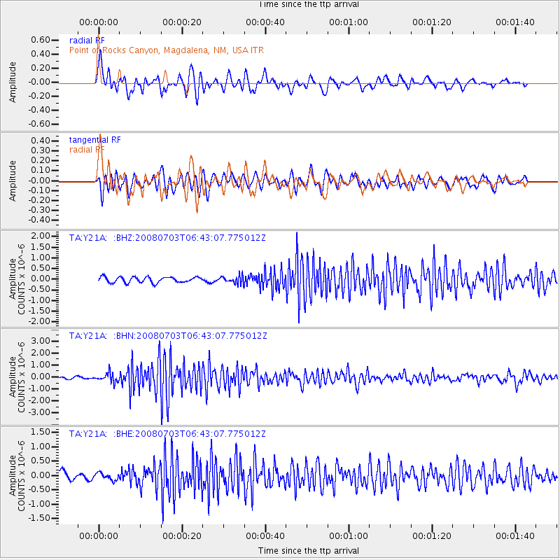
Y21A Point of Rocks Canyon, Magdalena, NM, USA |
| Lat/Lon: |
34.01 N/107.67 W |
| Elevation: |
2168 m |
|
| Distance: |
49.2 deg |
| Az: |
306.296 deg |
| Baz: |
107.28 deg |
| Ray Param: |
0.068806976 |
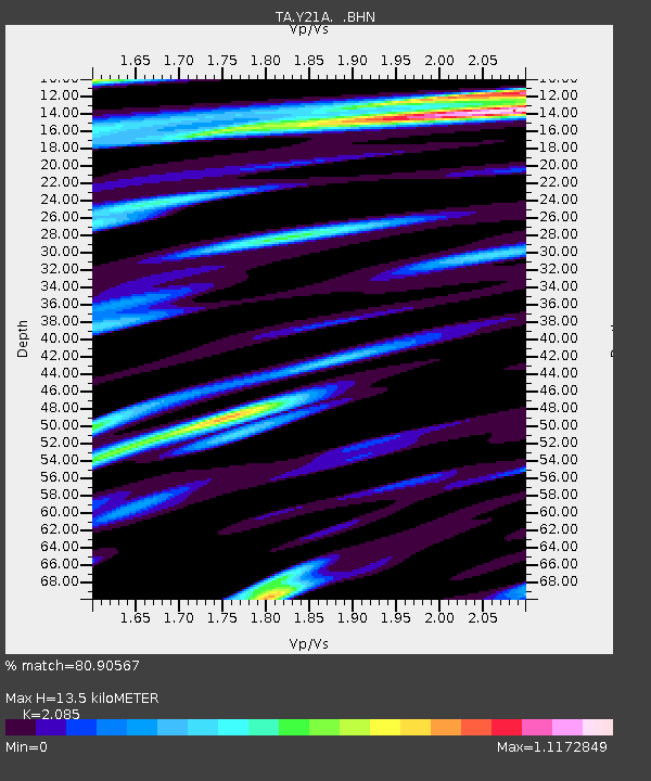
| Estimated Moho Depth: |
13.5 km |
| Estimated Crust Vp/Vs: |
2.09 |
| Assumed Crust Vp: |
6.502 km/s |
| Estimated Crust Vs: |
3.118 km/s |
| Estimated Crust Poisson's Ratio: |
0.35 |
|
| Radial Match: |
80.90567 % |
| Radial Bump: |
400 |
| Transverse Match: |
77.21152 % |
| Transverse Bump: |
400 |
| SOD ConfigId: |
2504 |
| Insert Time: |
2010-03-06 23:09:01.908 +0000 |
| GWidth: |
2.5 |
| Max Bumps: |
400 |
| Tol: |
0.001 |
|
Signal To Noise
| Channel | StoN | STA | LTA |
| TA:Y21A: :BHN:20080703T06:43:07.775012Z | 3.4079237 | 3.595525E-7 | 1.0550486E-7 |
| TA:Y21A: :BHE:20080703T06:43:07.775012Z | 0.86379486 | 1.2260391E-7 | 1.4193637E-7 |
| TA:Y21A: :BHZ:20080703T06:43:07.775012Z | 1.3357025 | 1.7408571E-7 | 1.303327E-7 |
| Arrivals |
| Ps | 2.4 SECOND |
| PpPs | 6.1 SECOND |
| PsPs/PpSs | 8.5 SECOND |


