You are here: Home > Network List > TA - USArray Transportable Network (new EarthScope stations) Stations List
> Station Y21A Point of Rocks Canyon, Magdalena, NM, USA > Earthquake Result Viewer
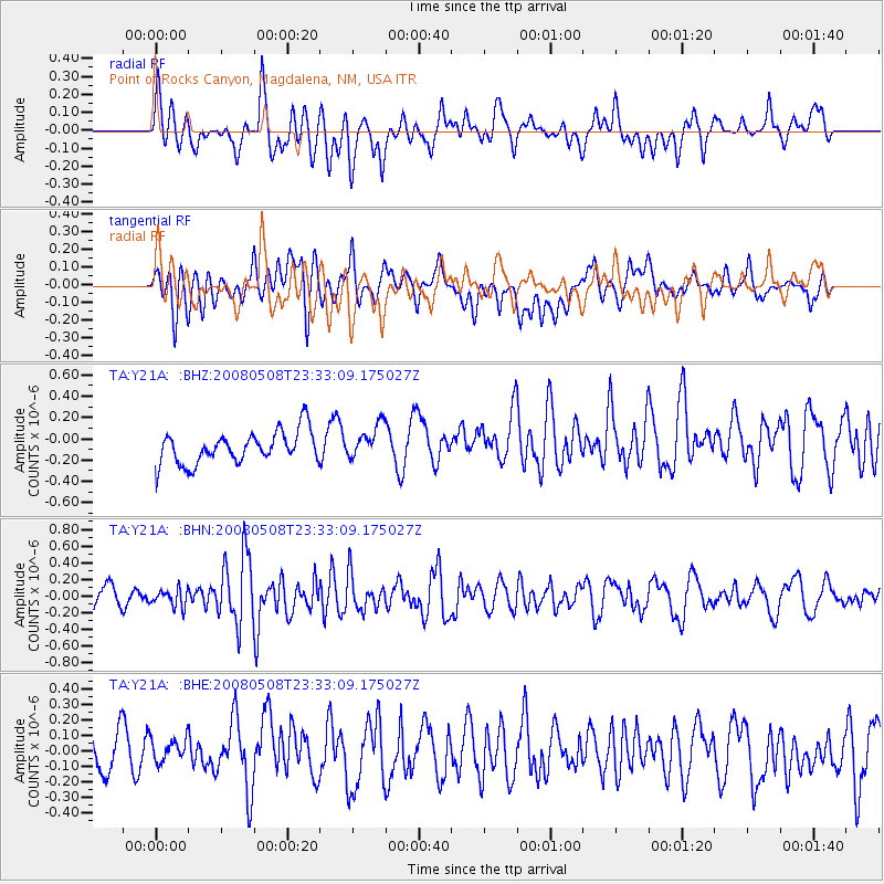
Y21A Point of Rocks Canyon, Magdalena, NM, USA - Earthquake Result Viewer
*The percent match for this event was below the threshold and hence no stack was calculated.
| Earthquake location: |
Near East Coast Of Honshu, Japan |
| Earthquake latitude/longitude: |
36.1/141.7 |
| Earthquake time(UTC): |
2008/05/08 (129) 23:21:06 GMT |
| Earthquake Depth: |
17 km |
| Earthquake Magnitude: |
5.6 MB, 5.2 MS, 5.6 MW, 5.5 MW |
| Earthquake Catalog/Contributor: |
WHDF/NEIC |
|
| Network: |
TA USArray Transportable Network (new EarthScope stations) |
| Station: |
Y21A Point of Rocks Canyon, Magdalena, NM, USA |
| Lat/Lon: |
34.01 N/107.67 W |
| Elevation: |
2168 m |
|
| Distance: |
84.9 deg |
| Az: |
51.305 deg |
| Baz: |
310.461 deg |
| Ray Param: |
$rayparam |
*The percent match for this event was below the threshold and hence was not used in the summary stack. |
|
| Radial Match: |
54.897797 % |
| Radial Bump: |
400 |
| Transverse Match: |
55.11432 % |
| Transverse Bump: |
400 |
| SOD ConfigId: |
2504 |
| Insert Time: |
2010-03-06 23:09:28.452 +0000 |
| GWidth: |
2.5 |
| Max Bumps: |
400 |
| Tol: |
0.001 |
|
Signal To Noise
| Channel | StoN | STA | LTA |
| TA:Y21A: :BHN:20080508T23:33:09.175027Z | 1.0860682 | 1.0546406E-7 | 9.71063E-8 |
| TA:Y21A: :BHE:20080508T23:33:09.175027Z | 0.5859882 | 8.838842E-8 | 1.5083651E-7 |
| TA:Y21A: :BHZ:20080508T23:33:09.175027Z | 1.0533167 | 1.5892682E-7 | 1.5088227E-7 |
| Arrivals |
| Ps | |
| PpPs | |
| PsPs/PpSs | |


