You are here: Home > Network List > TA - USArray Transportable Network (new EarthScope stations) Stations List
> Station Y21A Point of Rocks Canyon, Magdalena, NM, USA > Earthquake Result Viewer
Y21A Point of Rocks Canyon, Magdalena, NM, USA - Earthquake Result Viewer
*The percent match for this event was below the threshold and hence no stack was calculated.
| Earthquake location: |
Hokkaido, Japan Region |
| Earthquake latitude/longitude: |
41.5/139.0 |
| Earthquake time(UTC): |
2008/06/04 (156) 17:03:07 GMT |
| Earthquake Depth: |
213 km |
| Earthquake Magnitude: |
5.5 MB, 5.7 MW, 5.7 MW |
| Earthquake Catalog/Contributor: |
WHDF/NEIC |
|
| Network: |
TA USArray Transportable Network (new EarthScope stations) |
| Station: |
Y21A Point of Rocks Canyon, Magdalena, NM, USA |
| Lat/Lon: |
34.01 N/107.67 W |
| Elevation: |
2168 m |
|
| Distance: |
83.0 deg |
| Az: |
50.241 deg |
| Baz: |
315.99 deg |
| Ray Param: |
$rayparam |
*The percent match for this event was below the threshold and hence was not used in the summary stack. |
|
| Radial Match: |
76.78947 % |
| Radial Bump: |
400 |
| Transverse Match: |
75.51156 % |
| Transverse Bump: |
400 |
| SOD ConfigId: |
2504 |
| Insert Time: |
2010-03-06 23:09:31.507 +0000 |
| GWidth: |
2.5 |
| Max Bumps: |
400 |
| Tol: |
0.001 |
|
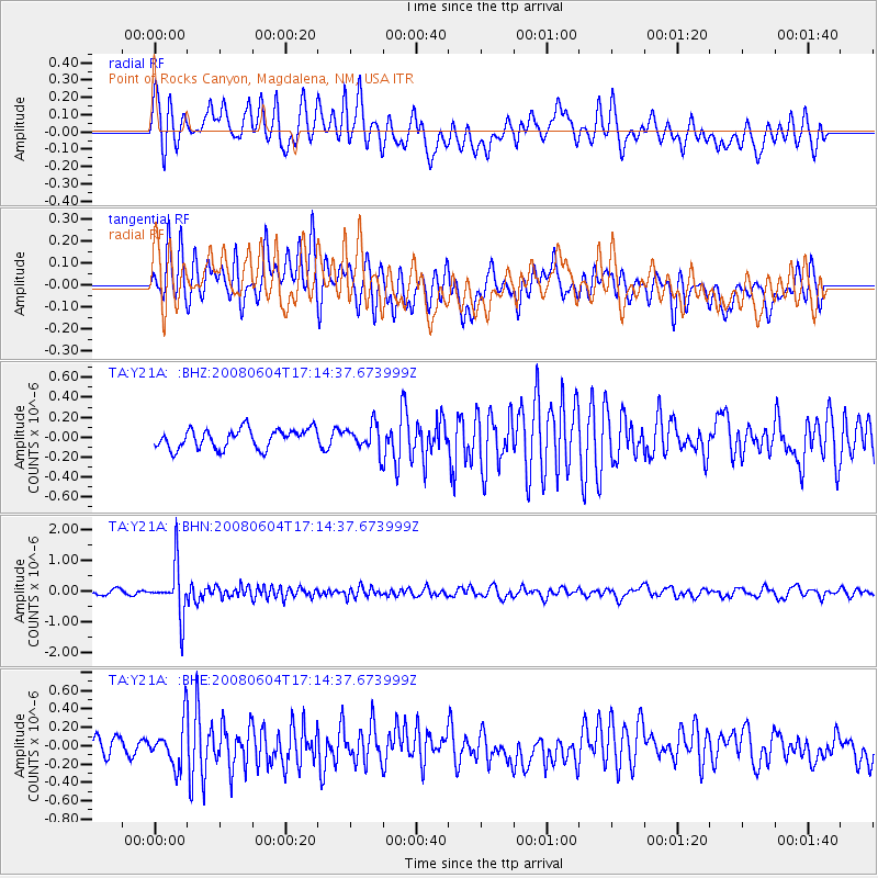
Signal To Noise
| Channel | StoN | STA | LTA |
| TA:Y21A: :BHN:20080604T17:14:37.673999Z | 11.141498 | 8.1088007E-7 | 7.278017E-8 |
| TA:Y21A: :BHE:20080604T17:14:37.673999Z | 2.3602989 | 2.3420792E-7 | 9.9228075E-8 |
| TA:Y21A: :BHZ:20080604T17:14:37.673999Z | 1.3556852 | 1.3213275E-7 | 9.746566E-8 |
| Arrivals |
| Ps | |
| PpPs | |
| PsPs/PpSs | |


