You are here: Home > Network List > TA - USArray Transportable Network (new EarthScope stations) Stations List
> Station Y21A Point of Rocks Canyon, Magdalena, NM, USA > Earthquake Result Viewer
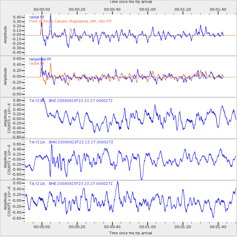
Y21A Point of Rocks Canyon, Magdalena, NM, USA - Earthquake Result Viewer
*The percent match for this event was below the threshold and hence no stack was calculated.
| Earthquake location: |
Tonga Islands |
| Earthquake latitude/longitude: |
-15.6/-173.4 |
| Earthquake time(UTC): |
2009/09/29 (272) 23:11:51 GMT |
| Earthquake Depth: |
10 km |
| Earthquake Magnitude: |
5.5 MB |
| Earthquake Catalog/Contributor: |
WHDF/NEIC |
|
| Network: |
TA USArray Transportable Network (new EarthScope stations) |
| Station: |
Y21A Point of Rocks Canyon, Magdalena, NM, USA |
| Lat/Lon: |
34.01 N/107.67 W |
| Elevation: |
2168 m |
|
| Distance: |
79.6 deg |
| Az: |
50.33 deg |
| Baz: |
243.239 deg |
| Ray Param: |
$rayparam |
*The percent match for this event was below the threshold and hence was not used in the summary stack. |
|
| Radial Match: |
56.4842 % |
| Radial Bump: |
339 |
| Transverse Match: |
55.583237 % |
| Transverse Bump: |
390 |
| SOD ConfigId: |
2622 |
| Insert Time: |
2010-03-06 23:10:02.024 +0000 |
| GWidth: |
2.5 |
| Max Bumps: |
400 |
| Tol: |
0.001 |
|
Signal To Noise
| Channel | StoN | STA | LTA |
| TA:Y21A: :BHN:20090929T23:23:27.000027Z | 0.6295827 | 2.1253341E-7 | 3.3757823E-7 |
| TA:Y21A: :BHE:20090929T23:23:27.000027Z | 0.7675483 | 1.8399075E-7 | 2.3971228E-7 |
| TA:Y21A: :BHZ:20090929T23:23:27.000027Z | 1.7004427 | 4.857846E-7 | 2.8568124E-7 |
| Arrivals |
| Ps | |
| PpPs | |
| PsPs/PpSs | |


