You are here: Home > Network List > TS - TERRAscope (Southern California Seismic Network) Stations List
> Station GPO China Lake , California, USA > Earthquake Result Viewer
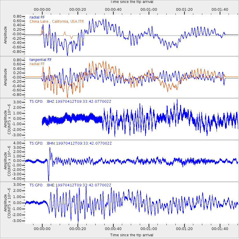
GPO China Lake , California, USA - Earthquake Result Viewer
*The percent match for this event was below the threshold and hence no stack was calculated.
| Earthquake location: |
Kermadec Islands Region |
| Earthquake latitude/longitude: |
-28.2/-178.4 |
| Earthquake time(UTC): |
1997/04/12 (102) 09:21:56 GMT |
| Earthquake Depth: |
184 km |
| Earthquake Magnitude: |
5.8 MB, 6.0 UNKNOWN, 6.0 MW |
| Earthquake Catalog/Contributor: |
WHDF/NEIC |
|
| Network: |
TS TERRAscope (Southern California Seismic Network) |
| Station: |
GPO China Lake , California, USA |
| Lat/Lon: |
35.65 N/117.66 W |
| Elevation: |
735 m |
|
| Distance: |
85.5 deg |
| Az: |
45.443 deg |
| Baz: |
230.57 deg |
| Ray Param: |
$rayparam |
*The percent match for this event was below the threshold and hence was not used in the summary stack. |
|
| Radial Match: |
74.6537 % |
| Radial Bump: |
400 |
| Transverse Match: |
71.533775 % |
| Transverse Bump: |
400 |
| SOD ConfigId: |
4480 |
| Insert Time: |
2010-02-26 14:14:38.988 +0000 |
| GWidth: |
2.5 |
| Max Bumps: |
400 |
| Tol: |
0.001 |
|
Signal To Noise
| Channel | StoN | STA | LTA |
| TS:GPO: :BHN:19970412T09:33:42.077002Z | 7.1846433 | 1.412133E-6 | 1.965488E-7 |
| TS:GPO: :BHE:19970412T09:33:42.077002Z | 1.41885 | 6.511419E-7 | 4.5892233E-7 |
| TS:GPO: :BHZ:19970412T09:33:42.077002Z | 1.2244246 | 6.5571794E-7 | 5.355315E-7 |
| Arrivals |
| Ps | |
| PpPs | |
| PsPs/PpSs | |


