You are here: Home > Network List > TA - USArray Transportable Network (new EarthScope stations) Stations List
> Station B18K Kokolik River, AK, USA > Earthquake Result Viewer
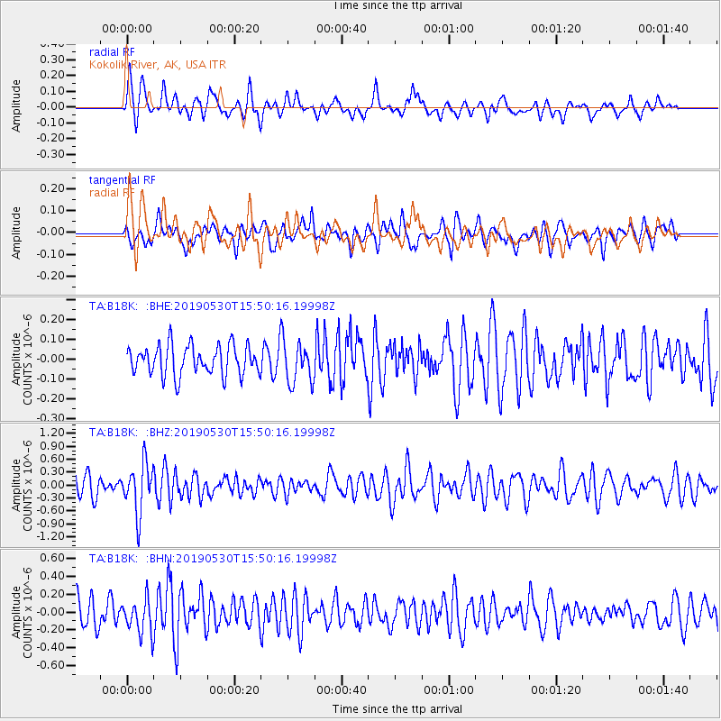
B18K Kokolik River, AK, USA - Earthquake Result Viewer
*The percent match for this event was below the threshold and hence no stack was calculated.
| Earthquake location: |
Fiji Islands Region |
| Earthquake latitude/longitude: |
-21.8/-176.3 |
| Earthquake time(UTC): |
2019/05/30 (150) 15:38:00 GMT |
| Earthquake Depth: |
169 km |
| Earthquake Magnitude: |
5.8 Mww |
| Earthquake Catalog/Contributor: |
NEIC PDE/us |
|
| Network: |
TA USArray Transportable Network (new EarthScope stations) |
| Station: |
B18K Kokolik River, AK, USA |
| Lat/Lon: |
69.36 N/161.80 W |
| Elevation: |
222 m |
|
| Distance: |
91.5 deg |
| Az: |
5.096 deg |
| Baz: |
193.468 deg |
| Ray Param: |
$rayparam |
*The percent match for this event was below the threshold and hence was not used in the summary stack. |
|
| Radial Match: |
67.9984 % |
| Radial Bump: |
400 |
| Transverse Match: |
62.26697 % |
| Transverse Bump: |
400 |
| SOD ConfigId: |
18369291 |
| Insert Time: |
2019-06-13 15:43:53.760 +0000 |
| GWidth: |
2.5 |
| Max Bumps: |
400 |
| Tol: |
0.001 |
|
Signal To Noise
| Channel | StoN | STA | LTA |
| TA:B18K: :BHZ:20190530T15:50:16.19998Z | 3.0226116 | 5.76996E-7 | 1.9089319E-7 |
| TA:B18K: :BHN:20190530T15:50:16.19998Z | 1.4059826 | 1.9391992E-7 | 1.3792484E-7 |
| TA:B18K: :BHE:20190530T15:50:16.19998Z | 1.3715185 | 1.0267952E-7 | 7.486558E-8 |
| Arrivals |
| Ps | |
| PpPs | |
| PsPs/PpSs | |


