You are here: Home > Network List > TA - USArray Transportable Network (new EarthScope stations) Stations List
> Station E20K Nigu River, AK, USA > Earthquake Result Viewer
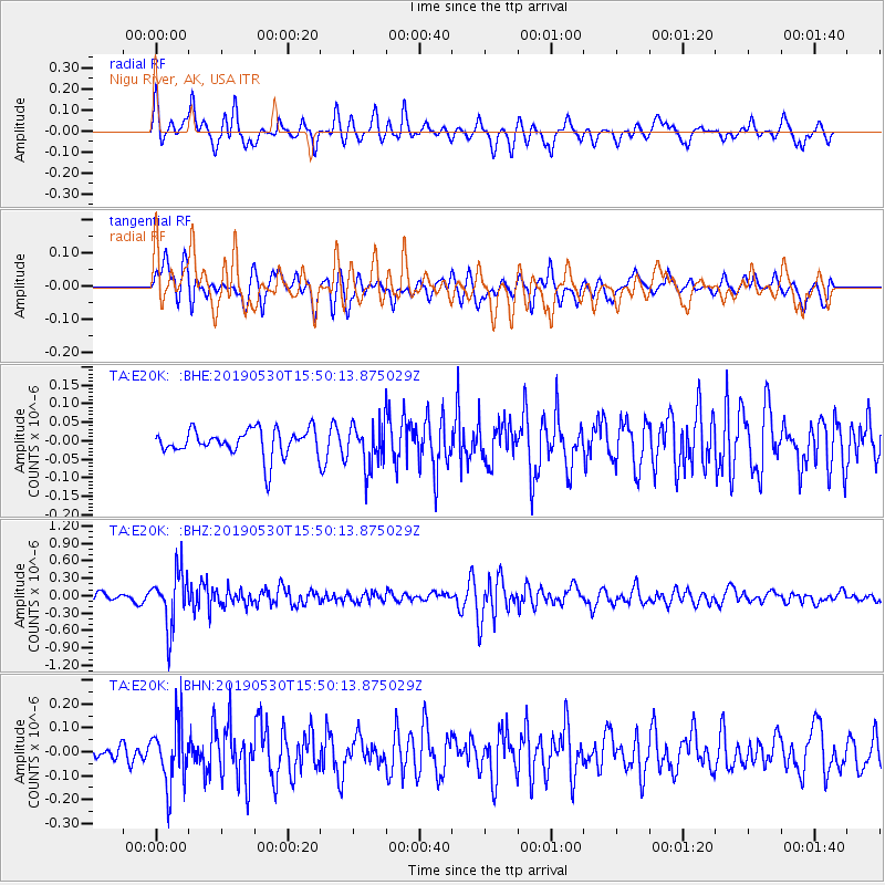
E20K Nigu River, AK, USA - Earthquake Result Viewer
*The percent match for this event was below the threshold and hence no stack was calculated.
| Earthquake location: |
Fiji Islands Region |
| Earthquake latitude/longitude: |
-21.8/-176.3 |
| Earthquake time(UTC): |
2019/05/30 (150) 15:38:00 GMT |
| Earthquake Depth: |
169 km |
| Earthquake Magnitude: |
5.8 Mww |
| Earthquake Catalog/Contributor: |
NEIC PDE/us |
|
| Network: |
TA USArray Transportable Network (new EarthScope stations) |
| Station: |
E20K Nigu River, AK, USA |
| Lat/Lon: |
68.26 N/156.19 W |
| Elevation: |
866 m |
|
| Distance: |
91.0 deg |
| Az: |
7.364 deg |
| Baz: |
198.649 deg |
| Ray Param: |
$rayparam |
*The percent match for this event was below the threshold and hence was not used in the summary stack. |
|
| Radial Match: |
65.60322 % |
| Radial Bump: |
400 |
| Transverse Match: |
68.49403 % |
| Transverse Bump: |
400 |
| SOD ConfigId: |
18369291 |
| Insert Time: |
2019-06-13 15:44:05.229 +0000 |
| GWidth: |
2.5 |
| Max Bumps: |
400 |
| Tol: |
0.001 |
|
Signal To Noise
| Channel | StoN | STA | LTA |
| TA:E20K: :BHZ:20190530T15:50:13.875029Z | 7.347914 | 4.589793E-7 | 6.246389E-8 |
| TA:E20K: :BHN:20190530T15:50:13.875029Z | 2.7669466 | 1.2595818E-7 | 4.5522444E-8 |
| TA:E20K: :BHE:20190530T15:50:13.875029Z | 1.6240299 | 5.7824984E-8 | 3.560586E-8 |
| Arrivals |
| Ps | |
| PpPs | |
| PsPs/PpSs | |


