You are here: Home > Network List > TA - USArray Transportable Network (new EarthScope stations) Stations List
> Station L16K Owhat River, AK, USA > Earthquake Result Viewer
L16K Owhat River, AK, USA - Earthquake Result Viewer
| Earthquake location: |
Fiji Islands Region |
| Earthquake latitude/longitude: |
-21.8/-176.3 |
| Earthquake time(UTC): |
2019/05/30 (150) 15:38:00 GMT |
| Earthquake Depth: |
169 km |
| Earthquake Magnitude: |
5.8 Mww |
| Earthquake Catalog/Contributor: |
NEIC PDE/us |
|
| Network: |
TA USArray Transportable Network (new EarthScope stations) |
| Station: |
L16K Owhat River, AK, USA |
| Lat/Lon: |
61.71 N/159.47 W |
| Elevation: |
227 m |
|
| Distance: |
84.3 deg |
| Az: |
7.969 deg |
| Baz: |
195.695 deg |
| Ray Param: |
0.045196854 |
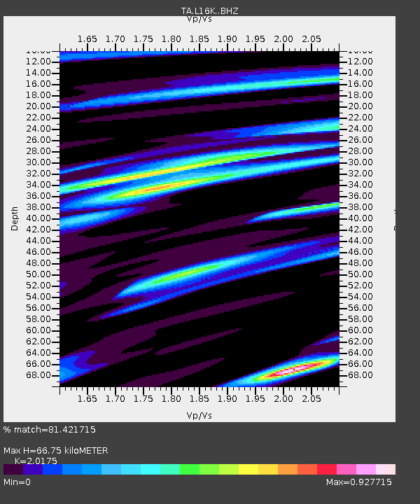
| Estimated Moho Depth: |
66.75 km |
| Estimated Crust Vp/Vs: |
2.02 |
| Assumed Crust Vp: |
6.276 km/s |
| Estimated Crust Vs: |
3.111 km/s |
| Estimated Crust Poisson's Ratio: |
0.34 |
|
| Radial Match: |
81.421715 % |
| Radial Bump: |
368 |
| Transverse Match: |
73.66979 % |
| Transverse Bump: |
400 |
| SOD ConfigId: |
18369291 |
| Insert Time: |
2019-06-13 15:44:51.426 +0000 |
| GWidth: |
2.5 |
| Max Bumps: |
400 |
| Tol: |
0.001 |
|

Signal To Noise
| Channel | StoN | STA | LTA |
| TA:L16K: :BHZ:20190530T15:49:41.975004Z | 8.4008665 | 1.0389068E-6 | 1.2366664E-7 |
| TA:L16K: :BHN:20190530T15:49:41.975004Z | 3.6061225 | 3.4992388E-7 | 9.703605E-8 |
| TA:L16K: :BHE:20190530T15:49:41.975004Z | 2.056741 | 2.7524385E-7 | 1.3382522E-7 |
| Arrivals |
| Ps | 11 SECOND |
| PpPs | 31 SECOND |
| PsPs/PpSs | 42 SECOND |


