You are here: Home > Network List > TA - USArray Transportable Network (new EarthScope stations) Stations List
> Station M15K Kasigluk River, AK, USA > Earthquake Result Viewer
M15K Kasigluk River, AK, USA - Earthquake Result Viewer
| Earthquake location: |
Fiji Islands Region |
| Earthquake latitude/longitude: |
-21.8/-176.3 |
| Earthquake time(UTC): |
2019/05/30 (150) 15:38:00 GMT |
| Earthquake Depth: |
169 km |
| Earthquake Magnitude: |
5.8 Mww |
| Earthquake Catalog/Contributor: |
NEIC PDE/us |
|
| Network: |
TA USArray Transportable Network (new EarthScope stations) |
| Station: |
M15K Kasigluk River, AK, USA |
| Lat/Lon: |
60.69 N/160.69 W |
| Elevation: |
210 m |
|
| Distance: |
83.1 deg |
| Az: |
7.667 deg |
| Baz: |
194.6 deg |
| Ray Param: |
0.04599447 |
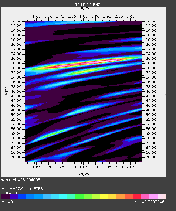
| Estimated Moho Depth: |
27.0 km |
| Estimated Crust Vp/Vs: |
1.93 |
| Assumed Crust Vp: |
6.182 km/s |
| Estimated Crust Vs: |
3.195 km/s |
| Estimated Crust Poisson's Ratio: |
0.32 |
|
| Radial Match: |
86.394005 % |
| Radial Bump: |
321 |
| Transverse Match: |
72.17265 % |
| Transverse Bump: |
396 |
| SOD ConfigId: |
18369291 |
| Insert Time: |
2019-06-13 15:44:58.809 +0000 |
| GWidth: |
2.5 |
| Max Bumps: |
400 |
| Tol: |
0.001 |
|

Signal To Noise
| Channel | StoN | STA | LTA |
| TA:M15K: :BHZ:20190530T15:49:36.19998Z | 7.9557815 | 1.4027046E-6 | 1.7631261E-7 |
| TA:M15K: :BHN:20190530T15:49:36.19998Z | 4.41042 | 6.610708E-7 | 1.4988841E-7 |
| TA:M15K: :BHE:20190530T15:49:36.19998Z | 0.9245643 | 1.5500639E-7 | 1.6765344E-7 |
| Arrivals |
| Ps | 4.2 SECOND |
| PpPs | 13 SECOND |
| PsPs/PpSs | 17 SECOND |


