You are here: Home > Network List > TA - USArray Transportable Network (new EarthScope stations) Stations List
> Station M16K Timber Creek, AK, USA > Earthquake Result Viewer
M16K Timber Creek, AK, USA - Earthquake Result Viewer
| Earthquake location: |
Fiji Islands Region |
| Earthquake latitude/longitude: |
-21.8/-176.3 |
| Earthquake time(UTC): |
2019/05/30 (150) 15:38:00 GMT |
| Earthquake Depth: |
169 km |
| Earthquake Magnitude: |
5.8 Mww |
| Earthquake Catalog/Contributor: |
NEIC PDE/us |
|
| Network: |
TA USArray Transportable Network (new EarthScope stations) |
| Station: |
M16K Timber Creek, AK, USA |
| Lat/Lon: |
61.02 N/158.96 W |
| Elevation: |
394 m |
|
| Distance: |
83.7 deg |
| Az: |
8.4 deg |
| Baz: |
196.192 deg |
| Ray Param: |
0.04561885 |
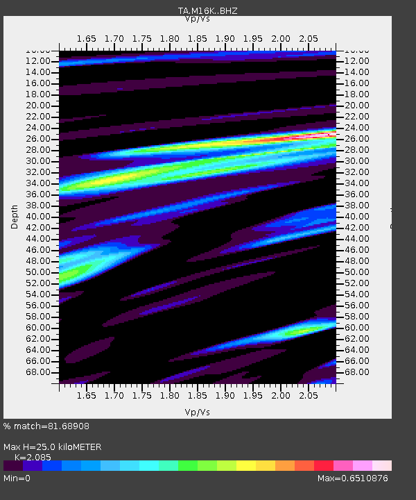
| Estimated Moho Depth: |
25.0 km |
| Estimated Crust Vp/Vs: |
2.09 |
| Assumed Crust Vp: |
6.276 km/s |
| Estimated Crust Vs: |
3.01 km/s |
| Estimated Crust Poisson's Ratio: |
0.35 |
|
| Radial Match: |
81.68908 % |
| Radial Bump: |
316 |
| Transverse Match: |
77.589775 % |
| Transverse Bump: |
400 |
| SOD ConfigId: |
18369291 |
| Insert Time: |
2019-06-13 15:44:58.901 +0000 |
| GWidth: |
2.5 |
| Max Bumps: |
400 |
| Tol: |
0.001 |
|

Signal To Noise
| Channel | StoN | STA | LTA |
| TA:M16K: :BHZ:20190530T15:49:38.94998Z | 13.3774605 | 1.6564342E-6 | 1.2382277E-7 |
| TA:M16K: :BHN:20190530T15:49:38.94998Z | 4.5407825 | 6.5609305E-7 | 1.4448898E-7 |
| TA:M16K: :BHE:20190530T15:49:38.94998Z | 0.8649222 | 1.1121663E-7 | 1.285857E-7 |
| Arrivals |
| Ps | 4.4 SECOND |
| PpPs | 12 SECOND |
| PsPs/PpSs | 16 SECOND |


