You are here: Home > Network List > TA - USArray Transportable Network (new EarthScope stations) Stations List
> Station M26K Nabesna, AK, USA > Earthquake Result Viewer
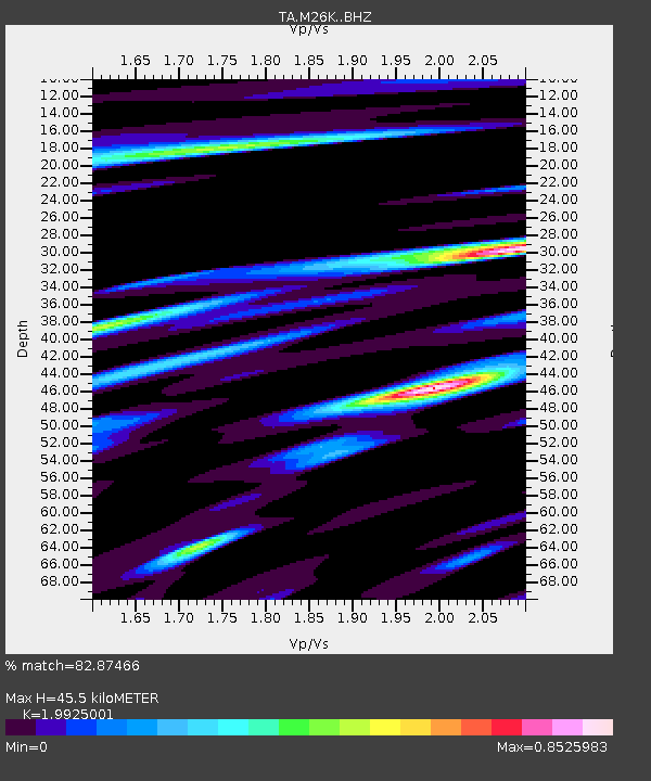
M26K Nabesna, AK, USA - Earthquake Result Viewer
| Earthquake location: |
Fiji Islands Region |
| Earthquake latitude/longitude: |
-21.8/-176.3 |
| Earthquake time(UTC): |
2019/05/30 (150) 15:38:00 GMT |
| Earthquake Depth: |
169 km |
| Earthquake Magnitude: |
5.8 Mww |
| Earthquake Catalog/Contributor: |
NEIC PDE/us |
|
| Network: |
TA USArray Transportable Network (new EarthScope stations) |
| Station: |
M26K Nabesna, AK, USA |
| Lat/Lon: |
62.40 N/143.00 W |
| Elevation: |
888 m |
|
| Distance: |
88.0 deg |
| Az: |
14.829 deg |
| Baz: |
210.717 deg |
| Ray Param: |
0.042551324 |
| Estimated Moho Depth: |
45.5 km |
| Estimated Crust Vp/Vs: |
1.99 |
| Assumed Crust Vp: |
6.566 km/s |
| Estimated Crust Vs: |
3.295 km/s |
| Estimated Crust Poisson's Ratio: |
0.33 |
|
| Radial Match: |
82.87466 % |
| Radial Bump: |
400 |
| Transverse Match: |
75.309364 % |
| Transverse Bump: |
400 |
| SOD ConfigId: |
18369291 |
| Insert Time: |
2019-06-13 15:45:04.548 +0000 |
| GWidth: |
2.5 |
| Max Bumps: |
400 |
| Tol: |
0.001 |
|

Signal To Noise
| Channel | StoN | STA | LTA |
| TA:M26K: :BHZ:20190530T15:49:59.925017Z | 6.783746 | 5.08422E-7 | 7.494708E-8 |
| TA:M26K: :BHN:20190530T15:49:59.925017Z | 3.7973652 | 2.2124291E-7 | 5.8262216E-8 |
| TA:M26K: :BHE:20190530T15:49:59.925017Z | 1.9692926 | 1.2596031E-7 | 6.3962204E-8 |
| Arrivals |
| Ps | 7.0 SECOND |
| PpPs | 20 SECOND |
| PsPs/PpSs | 27 SECOND |


