You are here: Home > Network List > UU - University of Utah Regional Network Stations List
> Station VRUT Veyo Road, Veyo, UT, USA > Earthquake Result Viewer
VRUT Veyo Road, Veyo, UT, USA - Earthquake Result Viewer
| Earthquake location: |
Fiji Islands Region |
| Earthquake latitude/longitude: |
-21.8/-176.3 |
| Earthquake time(UTC): |
2019/05/30 (150) 15:38:00 GMT |
| Earthquake Depth: |
169 km |
| Earthquake Magnitude: |
5.8 Mww |
| Earthquake Catalog/Contributor: |
NEIC PDE/us |
|
| Network: |
UU University of Utah Regional Network |
| Station: |
VRUT Veyo Road, Veyo, UT, USA |
| Lat/Lon: |
37.46 N/113.86 W |
| Elevation: |
1874 m |
|
| Distance: |
83.2 deg |
| Az: |
45.278 deg |
| Baz: |
236.099 deg |
| Ray Param: |
0.04596974 |
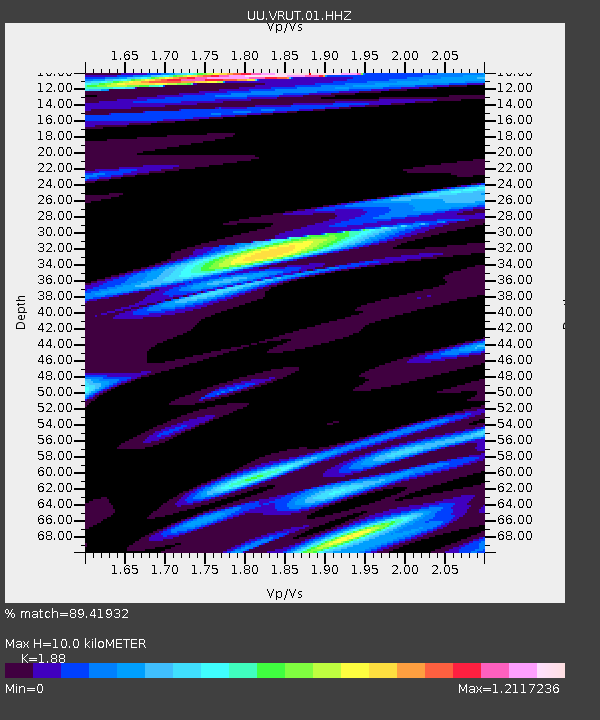
| Estimated Moho Depth: |
10.0 km |
| Estimated Crust Vp/Vs: |
1.88 |
| Assumed Crust Vp: |
6.194 km/s |
| Estimated Crust Vs: |
3.295 km/s |
| Estimated Crust Poisson's Ratio: |
0.30 |
|
| Radial Match: |
89.41932 % |
| Radial Bump: |
400 |
| Transverse Match: |
75.21675 % |
| Transverse Bump: |
325 |
| SOD ConfigId: |
18369291 |
| Insert Time: |
2019-06-13 15:46:38.220 +0000 |
| GWidth: |
2.5 |
| Max Bumps: |
400 |
| Tol: |
0.001 |
|

Signal To Noise
| Channel | StoN | STA | LTA |
| UU:VRUT:01:HHZ:20190530T15:49:36.379973Z | 1.692508 | 6.1858296E-9 | 3.6548304E-9 |
| UU:VRUT:01:HHN:20190530T15:49:36.379973Z | 1.1729373 | 4.5893462E-9 | 3.912695E-9 |
| UU:VRUT:01:HHE:20190530T15:49:36.379973Z | 0.9297237 | 3.281192E-9 | 3.529212E-9 |
| Arrivals |
| Ps | 1.5 SECOND |
| PpPs | 4.5 SECOND |
| PsPs/PpSs | 6.0 SECOND |


