You are here: Home > Network List > TA - USArray Transportable Network (new EarthScope stations) Stations List
> Station Y21A Point of Rocks Canyon, Magdalena, NM, USA > Earthquake Result Viewer
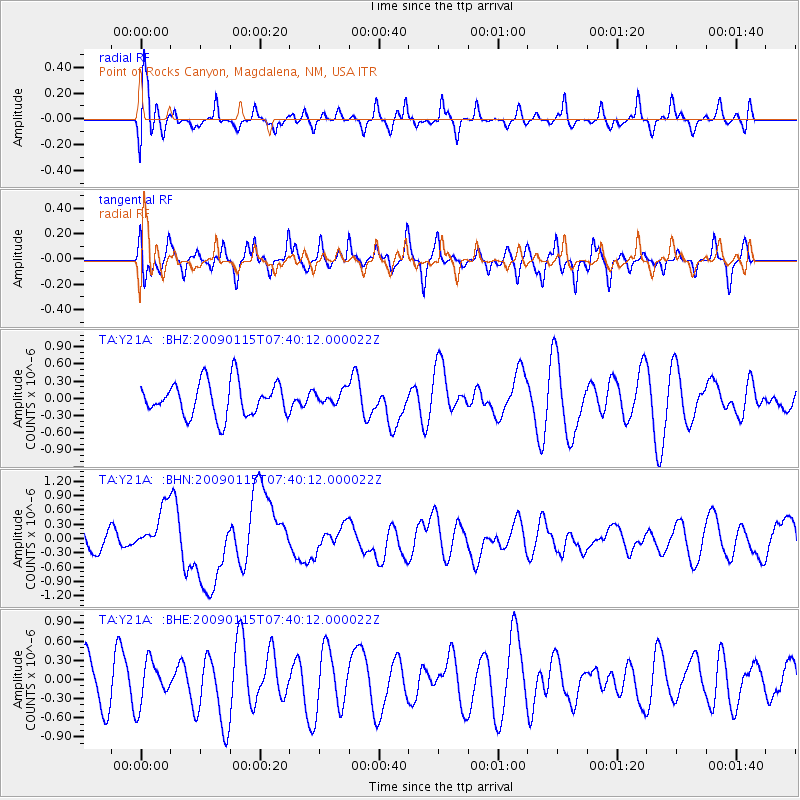
Y21A Point of Rocks Canyon, Magdalena, NM, USA - Earthquake Result Viewer
*The percent match for this event was below the threshold and hence no stack was calculated.
| Earthquake location: |
Southeast Of Loyalty Islands |
| Earthquake latitude/longitude: |
-22.4/170.6 |
| Earthquake time(UTC): |
2009/01/15 (015) 07:27:20 GMT |
| Earthquake Depth: |
27 km |
| Earthquake Magnitude: |
5.8 MB, 6.5 MS, 6.7 MW, 6.6 MW |
| Earthquake Catalog/Contributor: |
WHDF/NEIC |
|
| Network: |
TA USArray Transportable Network (new EarthScope stations) |
| Station: |
Y21A Point of Rocks Canyon, Magdalena, NM, USA |
| Lat/Lon: |
34.01 N/107.67 W |
| Elevation: |
2168 m |
|
| Distance: |
95.7 deg |
| Az: |
55.696 deg |
| Baz: |
247.014 deg |
| Ray Param: |
$rayparam |
*The percent match for this event was below the threshold and hence was not used in the summary stack. |
|
| Radial Match: |
61.41673 % |
| Radial Bump: |
400 |
| Transverse Match: |
67.873924 % |
| Transverse Bump: |
379 |
| SOD ConfigId: |
2834 |
| Insert Time: |
2010-03-06 23:11:21.006 +0000 |
| GWidth: |
2.5 |
| Max Bumps: |
400 |
| Tol: |
0.001 |
|
Signal To Noise
| Channel | StoN | STA | LTA |
| TA:Y21A: :BHN:20090115T07:40:12.000022Z | 1.9050858 | 4.7878353E-7 | 2.5131862E-7 |
| TA:Y21A: :BHE:20090115T07:40:12.000022Z | 0.9985029 | 3.3397484E-7 | 3.3447557E-7 |
| TA:Y21A: :BHZ:20090115T07:40:12.000022Z | 0.4067807 | 1.2080054E-7 | 2.9696724E-7 |
| Arrivals |
| Ps | |
| PpPs | |
| PsPs/PpSs | |


