You are here: Home > Network List > TS - TERRAscope (Southern California Seismic Network) Stations List
> Station GPO China Lake , California, USA > Earthquake Result Viewer
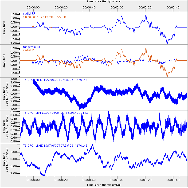
GPO China Lake , California, USA - Earthquake Result Viewer
*The percent match for this event was below the threshold and hence no stack was calculated.
| Earthquake location: |
Southeast Of Loyalty Islands |
| Earthquake latitude/longitude: |
-21.3/171.5 |
| Earthquake time(UTC): |
1997/06/09 (160) 07:24:12 GMT |
| Earthquake Depth: |
33 km |
| Earthquake Magnitude: |
5.4 MB, 5.6 MS, 6.0 UNKNOWN, 5.9 MW |
| Earthquake Catalog/Contributor: |
WHDF/NEIC |
|
| Network: |
TS TERRAscope (Southern California Seismic Network) |
| Station: |
GPO China Lake , California, USA |
| Lat/Lon: |
35.65 N/117.66 W |
| Elevation: |
735 m |
|
| Distance: |
87.7 deg |
| Az: |
50.331 deg |
| Baz: |
241.78 deg |
| Ray Param: |
$rayparam |
*The percent match for this event was below the threshold and hence was not used in the summary stack. |
|
| Radial Match: |
14.738664 % |
| Radial Bump: |
400 |
| Transverse Match: |
44.13767 % |
| Transverse Bump: |
400 |
| SOD ConfigId: |
4480 |
| Insert Time: |
2010-02-26 14:14:41.899 +0000 |
| GWidth: |
2.5 |
| Max Bumps: |
400 |
| Tol: |
0.001 |
|
Signal To Noise
| Channel | StoN | STA | LTA |
| TS:GPO: :BHN:19970609T07:36:26.427014Z | 0.76191854 | 2.3487824E-7 | 3.0827212E-7 |
| TS:GPO: :BHE:19970609T07:36:26.427014Z | 2.7346337 | 1.6782104E-6 | 6.1368746E-7 |
| TS:GPO: :BHZ:19970609T07:36:26.427014Z | 3.6057374 | 3.4919442E-6 | 9.684411E-7 |
| Arrivals |
| Ps | |
| PpPs | |
| PsPs/PpSs | |


